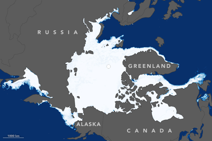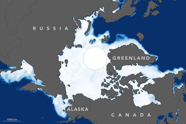


Arctic sea ice reached its annual maximum extent on March 24, 2016, according to scientists at the National Snow & Ice Data Center (NSIDC) and NASA. The annual peak was a record low for the second year in a row; that is, the ice cap grew less this winter than at any time since satellites have measured it.
Every year, the cap of frozen seawater floating on top of the Arctic Ocean and neighboring seas melts during the spring and summer and grows in the fall and winter. This ice reaches its maximum extent between February and April.
On March 24, Arctic sea ice extent peaked at 14.52 million square kilometers (5.607 million square miles)—the smallest “maximum” since satellite measurements started in 1979. The 2016 total is slightly smaller than the previous record low of 14.54 million square kilometers (5.612 million square miles) set in February 2015. The 13 smallest maxima have all occurred in the past 13 years.
The maps above show Arctic sea ice extent on March 24, 2016 (top), and March 14, 1983 (bottom). Extent is defined as the total area in which the ice concentration is at least 15 percent. According to NSIDC, the average maximum extent for 1979–2000 was 15.46 million square kilometers (5.96 million square miles). The 1983 maximum covered roughly that extent, so a comparison between 2016 and 1983 gives an idea of how conditions this year strayed from the long-term average. Turn on the image-comparison tool to see the difference.
The low sea ice maximum coincides with record high air temperatures in December, January, and February in the Arctic and around the planet. According to Walt Meier, a sea ice scientist at NASA’s Goddard Space Flight Center, the atmospheric warmth contributed to the low ice extent, as air temperatures along the edges of the ice pack—where sea ice is thin—were as much as nearly 6 degrees Celsius (10 degrees Fahrenheit) above average. Wind patterns in the Arctic were also unfavorable; southerly winds in January and February brought warm air and also prevented ice cover from moving toward lower latitudes.
Meier notes that, ultimately, warming ocean waters will play a bigger role in the future of Arctic ice. “It is likely that we’re going to keep seeing smaller wintertime maximums because, in addition to a warmer atmosphere, the ocean has warmed up. That warmer ocean will not let the ice edge expand as far south as it used to,” Meier said. “Although the maximum reach of the sea ice can vary a lot each year depending on winter weather conditions, we’re seeing a significant downward trend, and that’s ultimately related to the warming atmosphere and oceans.”
Since 1979, the Arctic has lost 1,600,000 square kilometers (620,000 square miles) of winter sea ice cover—an area more than twice the size of Texas. This year’s record low sea ice maximum extent will not necessarily result in a record low summertime minimum, Meier noted. Summer weather conditions have a larger impact on the outcome of each year’s melt season. Warm temperatures and summer storms make the ice melt faster; if a summer is cool, the melt slows down.
NASA Earth Observatory images by Jesse Allen, using data from the Advanced Microwave Scanning Radiometer 2 (AMSR-2) sensor on the Global Change Observation Mission 1st-Water (GCOM-W1) satellite and the Scanning Multichannel Microwave Radiometer (SMMR) on the Nimbus-7 satellite. Caption by Maria-José Viñas, adapted for Earth Observatory by Kathryn Hansen.