In its seasonal bushfire outlook, Australia’s national council for fire and emergency services warned that severe rainfall deficits spanning 18 months had caused a substantial amount of dead and dry plant material to accumulate in Victoria’s forests, making it easier for fires to start and spread.
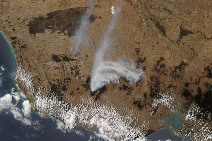
In January 2025, the warning became reality in the southeastern Australian state as bushfires raged in Grampians National Park and Little Desert National Park amid hot, dry, and windy conditions. The MODIS (Moderate Resolution Imaging Spectroradiometer) on NASA’s Aqua satellite captured this image of smoke streaming from bushfires burning through parts of the two national parks on January 28, 2025.
The fast-moving fires started on January 27 after dry thunderstorms and lightning struck the region, according to news reports. Unusually high temperatures, which reached above 40 degrees Celsius (104 degrees Fahrenheit), helped fuel the fires. The outbreak follows a similar surge in fire activity that occurred in Victoria in December 2024. At that time, a fire burned in the eastern part of Grampians National Park; this time the burning is centered on the western part of the park.
Victoria officials issued orders on January 29 for residents of Woohlpooer to “leave immediately,” due to increased fire activity on the northwestern edge of the fire. The blaze had crossed a road called Harrops Track and was heading in a northwesterly direction toward Billywing Track. They urged communities surrounding Little Desert National Park to “watch and act,” noting that the fire may travel in a northerly direction toward private properties.
NASA Earth Observatory image by Wanmei Liang, using MODIS data from NASA EOSDIS LANCE and GIBS/Worldview. Story by Adam Voiland.