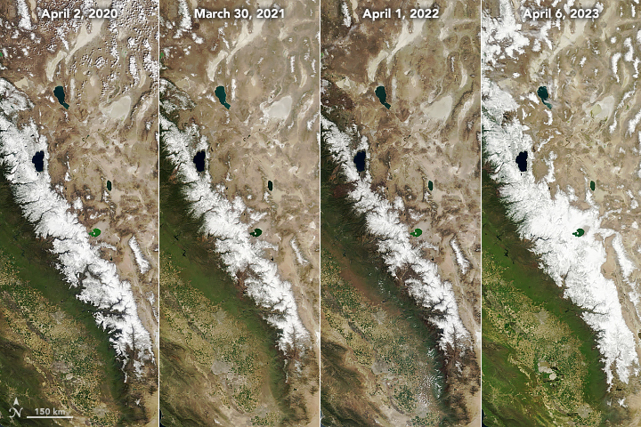

Today’s story compares the 2022 and 2023 snowpack in the Sierra Nevada. To see changes in the snowpack since 2006, visit our World of Change series.
After three years of busts, 2023 was a boom year for snow in the Sierra Nevada. Precipitation from a deluge of atmospheric rivers blanketed the California mountain range with a historic amount of snow.
Many parts of central California received 200 percent or more of expected precipitation this water year, which started on October 1. Eleven moderate-strength atmospheric rivers hit the southern Sierra Nevada this year, which is twice the average number. Precipitation from these storms contributed to a breach of the Los Angeles Aqueduct, the re-emergence of Tulare Lake in the San Joaquin River Valley, and heaps of snow on the range.
The natural-color satellite images above, acquired by the Moderate Resolution Imaging Spectroradiometer (MODIS) on NASA’s Terra satellite, show the stark difference between the snow cover in the Sierra Nevada on April 6, 2023 (right) compared to April 1, 2022 (left).
“Not only was this year wet, it was also unusually cold,” said Noah Molotch, a mountain hydrologist at the Institute of Arctic and Alpine Research (INSTAAR) and NASA’s Jet Propulsion Laboratory. Parts of the central coast experienced the coldest winter since 1978-1979, according to the National Weather Service. “This has contributed to an anomalously high snowpack in both the southern Sierra Nevada Mountains and at lower elevations along the range.”
Molotch and colleagues at INSTAAR have been using satellite data to track snowpack along the range every two weeks. Their analysis on April 1—which is typically the date of peak snowpack—confirmed that the season was a boom. “This is the greatest amount of snow water content we have seen in the Sierra Nevada since our record began in 2000,” Molotch said.
The map below shows snow water equivalent (SWE)—a measurement of how much water you would get if all of the snow in a given area melted at once. The measurement was particularly high in the southern Sierras: four times (439 percent) the average for April 1, according to Molotch’s analysis. Mountains in the central part of the range were at 284 percent of normal, and slopes to the north were 271 percent of normal.
The near real-time analysis of snow in the range relies on 20 years of data from the MODIS instruments on NASA’s Terra and Aqua satellites. NASA’s Shuttle Radar Topography Mission (SRTM) data on topography, among others, are also used to model mountain conditions.
Using ground-based measurements, the California Department of Water Resources (CA-DWR) also found that this year’s snowpack is one of the largest. Their survey of 130 ground-based snow sensors throughout the state indicated that the snow water equivalent on April 3 was 61 inches (1.55 meters), or 237 percent of average for that day. “This year’s result will go down as one of the largest snowpack years on record in California,” said Sean de Guzman, manager of CA-DWR’s Snow Surveys and Water Supply Forecasting Unit, in a press release. The only other time snowpack was this high was in 1952, but the system for measuring snow was different, making it difficult to make comparisons.

Snow that falls in the Sierra Nevada each winter is a natural reservoir that slowly melts and flows down into the river valleys in spring and summer. In a typical year, this snowpack accounts for about 30 percent of California’s water supply. This year, some reservoirs are so full that water managers are having to release water to make room for more snowmelt. This year’s exceptionally high snowpack was preceded by three years of extreme drought in the western U.S.
Data provided by Molotch and INSTAAR colleagues Leanne Lestak and Kehan Yang provide a detailed picture of snowpack across the range and at different elevations, which helps CA-DWR and other water managers better forecast snowmelt. Funding for the product was originally provided by NASA’s applied sciences program, and it is now supported by CA-DWR.
NASA Earth Observatory images by Lauren Dauphin, using MODIS data from NASA EOSDIS LANCE and GIBS/Worldview and snow water equivalent (SWE) data courtesy of the University of Colorado Boulder Institute of Arctic and Alpine Research. Story by Emily Cassidy.