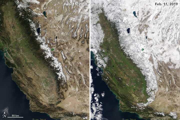


In Spanish, Sierra Nevada means “snowy mountain range.” During the past few months, the range has certainly lived up to its name. After a dry spell in December, a succession of storms in January and February 2019 blanketed the range.
In many areas, snow reports have been coming in feet not inches. Back-to-back storms in February dropped eleven feet (3 meters) of snow on Mammoth Mountain—enough to make it the snowiest ski resort in the United States. More than 37 feet (11 meters) have fallen at the resort since the beginning of winter, and meteorologists are forecasting that yet another storm will bring snow this week.
The Moderate Resolution Imaging Spectroradiometer (MODIS) acquired these natural-color images of the Sierra Nevada on February 11, 2019, and February 15, 2018. In addition to the much more extensive snow cover in 2019, notice the greener landscape on the western slopes of the range.
Statistics compiled by the California Department of Water Resources indicate that the mountain range had a snow water equivalent that was 146 percent of normal as of February 19, 2019. It was just 44 percent of normal on Thanksgiving 2018. Last season, on February 15, 2018, snow cover was at a mere 21 percent of normal.
Some of the snow has come courtesy of atmospheric rivers, a type of storm system known for transporting narrow, low-level plumes of moisture across long ocean distances and dumping tremendous amounts of precipitation on land.
The condition of Sierra Nevada snowpack has consequences that go well beyond ski season. Spring and summer melt from the Sierra Nevada plays a crucial role in recharging California’s reservoirs. Though conditions could change, California drought watchers are cautiously optimistic that the boost to the snowpack will insulate the state from drought this summer.
The reservoirs are already in pretty good shape. Cal Water data show that most of the reservoirs are already more than half-full, and several have water levels that are above the historical average for the middle of February.
NASA Earth Observatory images by Joshua Stevens, using MODIS data from NASA EOSDIS/LANCE and GIBS/Worldview. Story by Adam Voiland.