Since its creation in late April 1999, NASA Earth Observatory has published more than 15,000 image-driven stories about our planet: natural- and false-color satellite images, data maps, and aerial or space-based photos. In honor of our 20th anniversary, we offer a selection of some of the most beautiful, newsworthy, interesting, and scientifically important images from the past 20 years — one for each day of the calendar year. Check this page each day for a new blast from EO’s past.
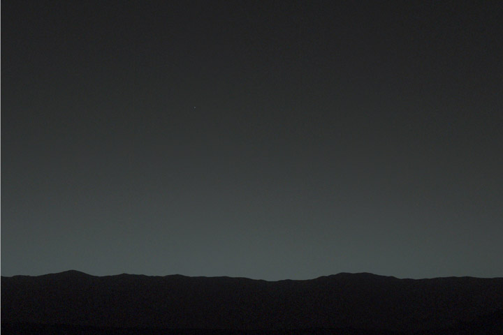
The Curiosity rover on Mars looked up and saw home on the horizon.
January • February • March • April • May • June • July • August • September • October • November • December
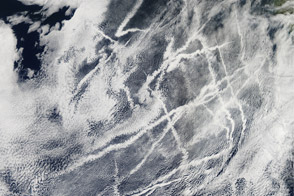
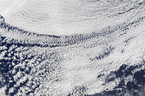
The narrow clouds form when water vapor condenses around tiny particles of pollution.
Published Mar 8, 2012
Researchers also found that human-ignited fires tripled the length of the wildfire season.
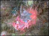
Published Mar 7, 2017
Satellites and scientists capture the Mackenzie River in the act of warming the ocean and breaking up ice in the Beaufort Sea.
Published Mar 6, 2014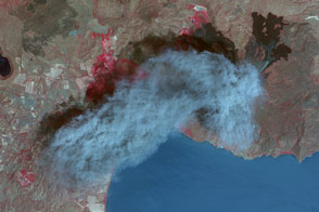
The Nicaraguan volcano erupted for the first time in more than a century.
Published Mar 5, 2016
A magnitude 6.3 earthquake that ravaged Christchurch also broke 30 million tons of ice off the Tasman Glacier.
Published Mar 4, 2011
Landsat 5 observed the growth of one of the largest surface mines in the state it expanded from ridge to ridge.
Published Mar 3, 2010
Earth-observing satellites follow the shadow of an annular eclipse.
Published Mar 2, 2017
A diamond-shaped piece of ice is a stranger amid thin ice.
Published Mar 1, 2017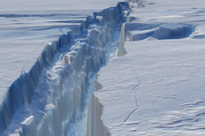
Scientists merged photographs and laser altimetry data to create a virtual journey through the crack in Antarctica's Pine Island Glacier.
Published Feb 29, 2012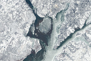
Record-setting cold temperatures iced up harbors and waterways across the eastern United States.
Published Feb 28, 2015Image of the Day Heat Severe Storms Snow and Ice Temperature Extremes
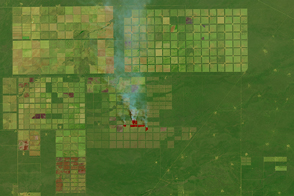
Ranching and farming operations have left a distinctive grid on the landscape.
Published Feb 27, 2016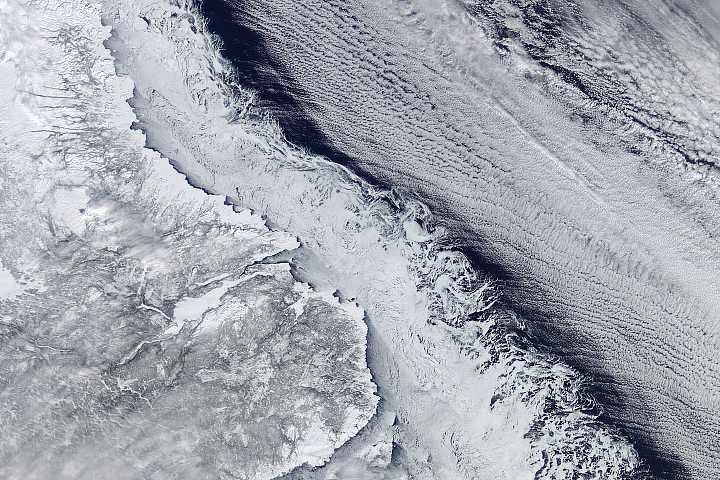
Cold winter winds helped paint a lovely scene off the coast of Labrador and Newfoundland.
Published Feb 26, 2018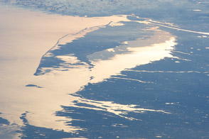
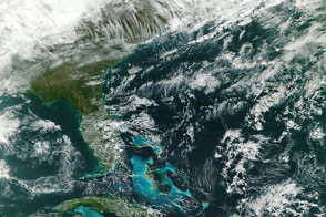
Reflected sunlight highlights the Atlantic Ocean, Buzzards Bay, and Long Island Sound in this photo from the space station.
Published Feb 25, 2013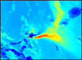
One of the most active volcanoes in the Aleutian Islands erupted in February 2001.
Published Feb 24, 2001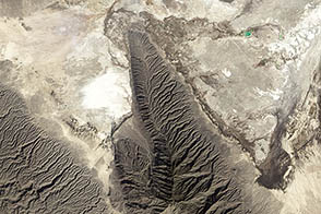
Mexico’s Cuatro Ciénegas Basin is one of the best places on Earth to investigate what life might have looked like on Mars.
Published Feb 23, 2013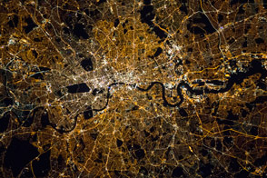
Astronauts aboard the International Space Station take special care to acquire crisp night shots.
Published Feb 22, 2016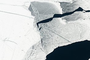
Ice cover surpassed 80 percent for the first time in 20 years.
Published Feb 21, 2014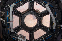
Primarily designed to give astronauts a way to see the outside of the ISS, it also provides stunning panoramic views of Earth and space.
Published Feb 20, 2010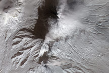
False-color images show Klyuchevskaya and Bezymianny releasing plumes over the snowy Kamchatka Peninsula.
Published Feb 19, 2010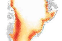
The ice-covered island’s melt season lasted 50 days longer than average.
Published Feb 18, 2011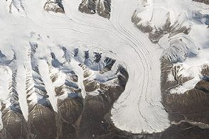
Colorful lakes and retreating glaciers are among the beautiful scenes waiting to be discovered within an image mosaic of the Arctic.
Published Feb 17, 2015
The underwater volcano near the Canary Islands is growing ever closer to the water surface.
Published Feb 16, 2012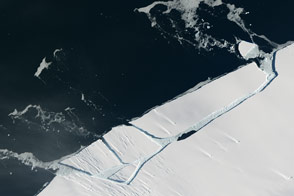
Pine Island Glacier has shed another block of ice into Antarctic waters.
Published Feb 15, 2017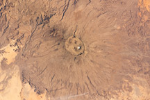
At 3,415 meters above sea level, the summit is the highest of Africa’s Sahara region.
Published Feb 14, 2011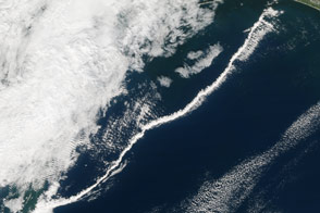
Downdrafts from thunderstorms sometimes fuel thin bands of cumulus clouds that race ahead of cold fronts.
Published Feb 13, 2016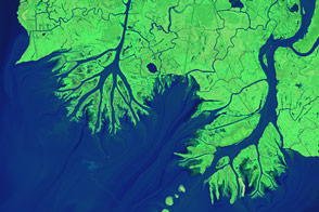
While most of the Mississippi River’s delta plain is losing ground, new land is forming at the mouths of the Wax Lake Outlet and the Atchafalaya River.
Published Feb 12, 2015
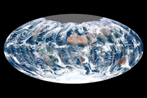
Using a collection of satellite images and data, scientists and visualizers stitched together months of observations of Earth’s land surface, oceans, sea ice, and clouds into a seamless, true-color mosaic.
Published Feb 11, 2002
The STEREO A spacecraft looked back from the far side of the Sun to capture an image of Earth and Mercury.
Published Feb 10, 2015
Also known as nacreous clouds, they play an important role in the depletion of stratospheric ozone.
Published Feb 9, 2011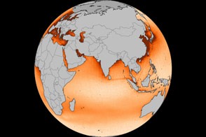
Elevated levels of nitrogen dioxide popped out over certain shipping lanes when observed by Aura.
Published Feb 8, 2013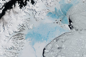
When this closely watched slab of floating ice births a giant iceberg, it will not be the first time it has seen dramatic change.
Published Feb 7, 2017Image of the Day Heat Land Water Snow and Ice Sea and Lake Ice
Whether a patch of clouds contains open or closed cells offers a clue about whether rain is falling below.
Published Feb 6, 2016
The summit of an active volcano is one of the most dynamic places on Earth, with changes apparent from one week to the next.
Published Feb 5, 2014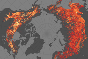
Research shows that very similar boreal landscapes produce very different types of fires.
Published Feb 4, 2015
Oil slicks stood out in the glare of the Sun in May 2006 on the Gulf of Mexico.
Published Feb 3, 2009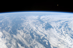
Astronauts on the last voyage of the space shuttle Columbia captured this view of clouds over the Atlantic Ocean.
Published Feb 2, 2013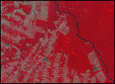
Just months after coming online, the ASTER instrument captured a view of forest clearing in Rondonia.
Published Feb 1, 2001
An eruption in the Aleutian Islands prompts a bloom of plankton 2000 miles downwind. The ocean soaks up carbon dioxide in the process, but not as much as you'd think.
Published Jan 31, 2013
Analysis of Landsat and MODIS data showed where agricultural production was affected by long-term drought in California.
Published Jan 30, 2015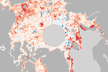
Satellite data revealed changes in the average start of spring melting and the first autumn freeze.
Published Jan 29, 2010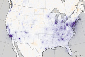
From 2005 to 2014, the Aura spacecraft observed increases in the air pollutant in some cities and decreases in others.
Published Jan 28, 2016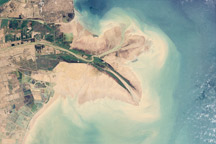
Chinese engineers changed the main channel through the delta, changing the shape of the land at the river’s mouth.
Published Jan 27, 2010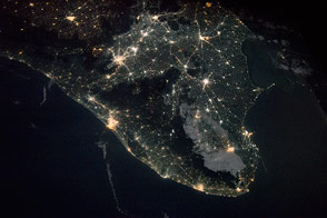
Two photos, taken 48 years apart, provide contrasting views of southern Asia.
Published Jan 26, 2015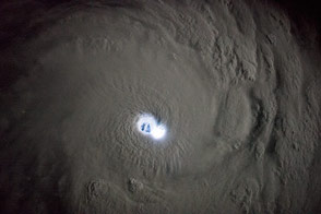
Lightning illuminated the center of the storm as the space station flew over at night.
Published Jan 25, 2015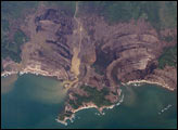
Astronaut photographs illustrate the damage along the southwestern coast of Aceh Province, Indonesia.
Published Jan 24, 2005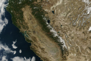
From brown landscapes to snow-free mountains, California was startlingly dry as a serious drought prompted a state of emergency.
Published Jan 23, 2014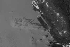
The Suomi NPP VIIRS “day-night band” makes it possible to view low clouds even at night—something earlier satellites have had difficulty doing.
Published Jan 22, 2013Image of the Day Atmosphere Fires Unique Imagery Human Presence
The world’s largest wind farm was planted just off of the mouth of the River Thames.
Published Jan 21, 2014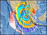
Sent into orbit to record the shape of the ocean’s surface, two satellites helped scientists understand a deadly tsunami in the Indian Ocean.
Published Jan 20, 2005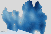
Scientists discovered a deepwater channel that could funnel warm water to the glacier's underbelly and melt it from below.
Published Jan 19, 2011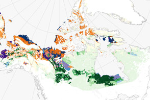
A holey, Swiss cheese-like landscape, thermokarst is distributed widely across the high latitudes of the northern hemisphere.
Published Jan 18, 2017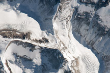
This astronaut photograph highlights the northern approach to the world’s tallest mountain.
Published Jan 17, 2011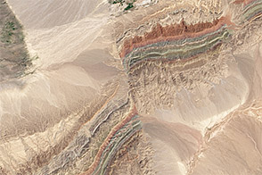
Colliding continents and cracks in the Earth’s crust make for some remarkable scenery in western China.
Published Jan 16, 2014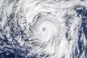
Alex is the earliest hurricane in the North Atlantic since 1938, and one of the farthest northeast on record.
Published Jan 15, 2016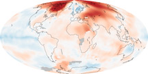
Four independent records are unequivocal: the world has warmed since 1880, and the past decade has been the warmest on record.
Published Jan 14, 2011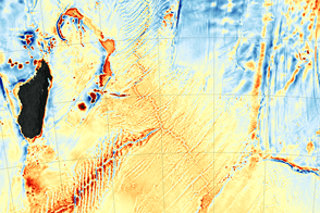
The recent discovery of the Mammerickx Microplate was made possible by new satellite-derived maps of the ocean floor.
Published Jan 13, 2016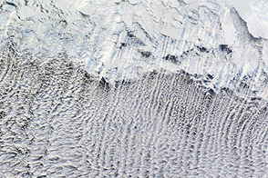
Most of us prefer our winter roads free of ice, but some cloud formations depend on it.
Published Jan 12, 2012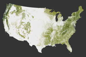
The National Biomass and Carbon Dataset reveals the location and the carbon storage of forests in the United States.
Published Jan 11, 2012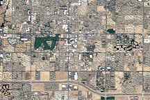
Acquired in 1989 and 2009, these images show rapid development of Chandler, Arizona, a “boomburb.”
Published Jan 10, 2010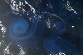
Late in 2013, a mid-summer bloom of phytoplankton gave color to a whirling eddy south of Australia.
Published Jan 9, 2014
In the winter, strong winds drive surface waters away from the shore, and cold water from the deep ocean wells up to replace it.
Published Jan 8, 2005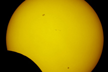
While the Moon was busy passing between the Sun and Earth for an eclipse in 2011, the space station made a cameo.
Published Jan 7, 2011
Kelp forests change frequently, and often out of sight from scientists. Infrared imagery changes that.
Published Jan 6, 2015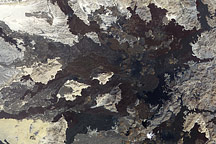
In northwestern Saudi Arabia lies a field of volcanic lava that contains some 50 cones from the past 10,000 years.
Published Jan 5, 2011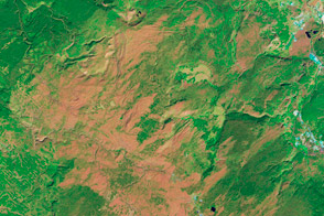
More than 20 years after intense fire scorched this national park, the ecosystem is still recovering.
Published Jan 4, 2012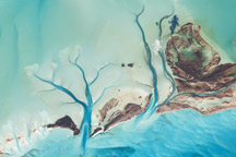
The islands are situated on large depositional platforms composed mainly of carbonate sediments and ringed by reefs.
Published Jan 3, 2011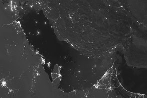
These satellite images illustrate the effects of moonlight on viewing this desert region.
Published Jan 2, 2013Image of the Day Fires Unique Imagery Human Presence Remote Sensing
The “southern lights” were bright enough to illuminate the ice below.
Published Jan 1, 2013Image of the Day Atmosphere Fires Unique Imagery Snow and Ice Remote Sensing
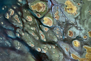
Water in Australia's salt lakes can be fleeting, but provides vital wetland habitat for plants and animals.
Published Dec 31, 2014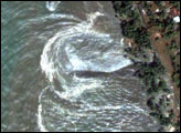
On December 26, 2004, tsunamis swept across the Indian Ocean, spawned by a magnitude 9.0 earthquake off the coast of Sumatra.
Published Dec 30, 2004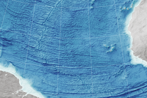
Scientists read the bumps on the ocean surface to understand the shape of the seafloor below.
Published Dec 29, 2015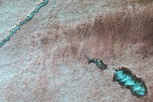
Cold winter conditions set the stage for these unusual clouds that can form due to airplane traffic.
Published Dec 28, 2010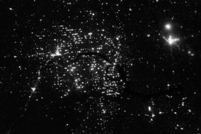
Cities and people are scarce in northwestern North Dakota, but nighttime satellite imagery shows the Bakken Formation aglow with brightly-lit drilling equipment.
Published Dec 27, 2012
In April 2001, researchers watched with surprise as dust from an Asian storm crossed the Pacific and reached the eastern United States.
Published Dec 26, 2007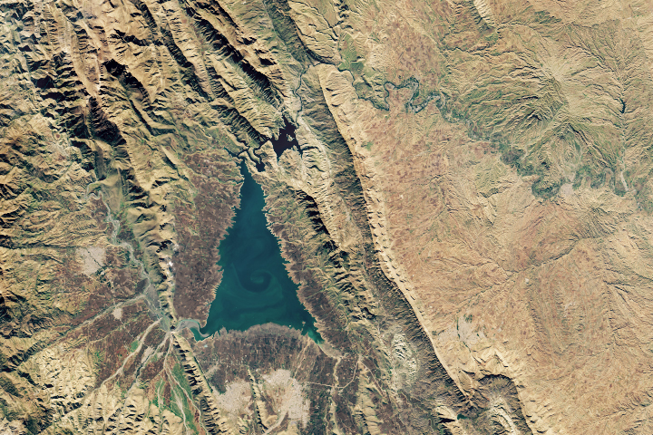
Shaped like an evergreen conifer, Lake Dukan is the largest lake in Iraqi Kurdistan.
Published Dec 25, 2018
These iconic photos are not new, but their message never gets old.
Published Dec 24, 2018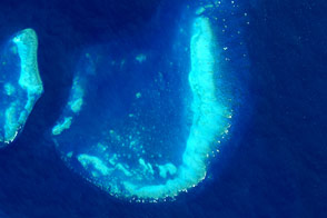
J brings us joy when we view it from space.
Published Dec 23, 2015
The Gulf Stream is a warm current amidst the cool North Atlantic. But the pattern is hardly uniform.
Published Dec 22, 2013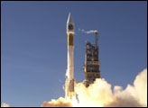
The flagship of NASA’s modern Earth-observing satellite fleet launched from Vandenberg Air Force Base on December 18, 1999.
Published Dec 21, 1999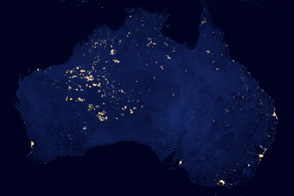
What are those lights in the Outback?
Published Dec 20, 2012Image of the Day Land Fires Unique Imagery Human Presence Remote Sensing
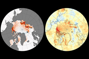
Satellites confirm that the Arctic has been absorbing more solar radiation over the past 15 years, a trend that coincides with a decline in sea ice and increase in open water.
Published Dec 19, 2014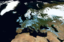
This trio of global maps illustrates how snow and clouds make Earth more reflective.
Published Dec 18, 2009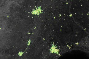
Satellite data reveals increases in December holiday lighting in the United States, mostly in the suburbs.
Published Dec 17, 2014Image of the Day Unique Imagery Human Presence Remote Sensing
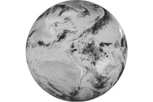
Looking down from 512 miles, the newly launched NPP satellite offers up its first gap-free view of Earth.
Published Dec 16, 2011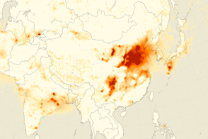
A decade of satellite observations show how levels of a common air pollutant have changed over Asian skies.
Published Dec 15, 2015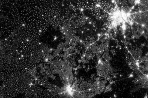
New images from Suomi NPP are an order of magnitude better than previous satellite views of city lights.
Published Dec 14, 2012Image of the Day Land Fires Unique Imagery Human Presence Remote Sensing
Several inches of wet snow fell across Louisiana, Mississippi, and Alabama in December 2008.
Published Dec 13, 2008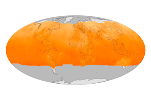
NASA’s Orbiting Carbon Observatory-2 has compiled its first year of data and started quantifying the cycles of emission and absorption of the greenhouse gas.
Published Dec 12, 2015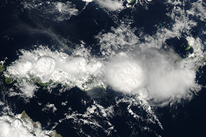
Impressive thunderclouds run along the spine of the Indonesian island of Flores, a result of ocean breezes and steep mountains.
Published Dec 11, 2013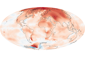
The average global temperature has increased by about 0.8°Celsius since 1880, and two-thirds of the warming occurred after 1975.
Published Dec 10, 2010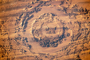
Photographs taken by astronauts on the ISS in 2003 and 2013 show the evolution of a dune field in Chad.
Published Dec 9, 2013
Landsat instruments have peered into the hot-water plumbing beneath some of the park’s famous monuments.
Published Dec 8, 2011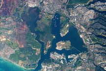
An astronaut captured this photo of the historic stretch of southern coastline of Oahu.
Published Dec 7, 2009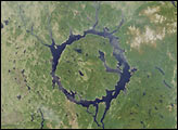
The impact that formed the lake is thought to have occurred about 200 million years ago and may have caused a mass extinction event.
Published Dec 6, 2001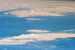
Astronauts on the ISS captured an unusual, airplane-like view of the Antarctic Peninsula and nearby islands.
Published Dec 5, 2011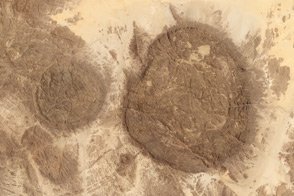
Like islands of stone surrounded by a sea of sand, the Aïr Mountains sustain a vibrant pocket of life in the Sahara.
Published Dec 4, 2013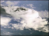
Astronauts used the Electrical Still Camera (ESC) to photograph a mass of storm clouds during Expedition 1.
Published Dec 3, 2000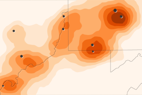
Scientists using a NASA satellite found that sulfur dioxide levels in the vicinity of major coal-fired power plants in the U.S. have fallen by half since 2005.
Published Dec 2, 2011
Astronauts use the Sun’s reflection point to reveal features that are otherwise difficult or impossible to see.
Published Dec 1, 2014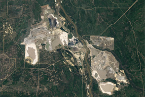
The clay, sand, and other minerals coated in thick, viscous bitumen are a source of oil, economic growth, and environmental concern.
Published Nov 30, 2011
In perhaps the driest place on Earth, water still shapes the landscape.
Published Nov 29, 2011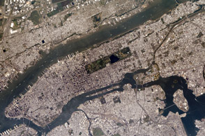
The most populous city in the United States has several connections to this national holiday.
Published Nov 28, 2013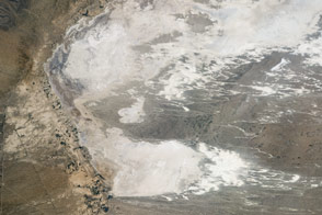
These white mounds are the world’s largest gypsum dune field, centerpiece of the White Sands National Monument.
Published Nov 27, 2016
Between 1990 and 2000, Paraguay lost about 13 percent of its forests, including nearly 40 percent of the Atlantic Forest.
Published Nov 26, 2009
Views from the ground and from space are helping scientists understand how soil moisture affects U.S. agriculture.
Published Nov 25, 2015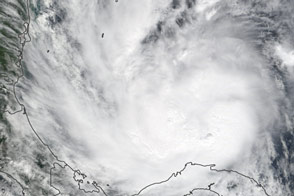
A new Earth-observing satellite opened its eyes for the first time and captured this natural-color view of eastern North America.
Published Nov 23, 2011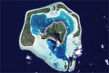
Low-profile fringing islands and coral reefs surround a relatively tall central island.
Published Nov 22, 2009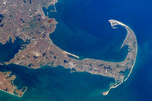
Cape Cod is a haven for rocks and people who have washed up on American shores.
Published Nov 21, 2010
Typhoon Haiyan’s winds and storm surge caused widespread damage to the coastal city.
Published Nov 20, 2013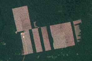
Free, open-access imagery helps scientists monitor remote areas and protect tropical forests.
Published Nov 19, 2013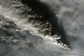
In November 2014, Alaska’s most active volcano rumbled back to life.
Published Nov 18, 2014
Landsat 5 captured a ring of radiation fog lingering in valley bottoms and above lakes in northwestern Patagonia.
Published Nov 17, 2012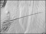
Pine Island Glacier has undergone a steady thinning in recent decades. In December 2000, satellites detected a wide new crack.
Published Nov 16, 2001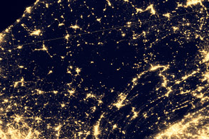
Areas recognized for their pristine dark skies are the perfect place to catch a glimpse of celestial phenomena.
Published Nov 15, 2014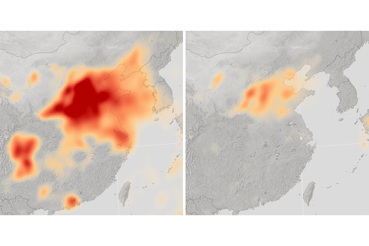
Pollution controls can work even as coal-usage continues.
Published Nov 14, 2017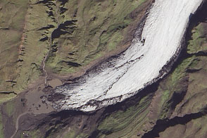
Climate and volcanoes transform an ice cap in Iceland.
Published Nov 13, 2014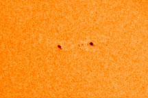
After a slow start, a pair of sunspots in late 2008 signaled an upswing in Solar Cycle 24.
Published Nov 12, 2008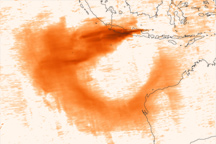
The volcano released sulfur dioxide, a colorless gas that can harm human health and cool Earth’s climate.
Published Nov 11, 2010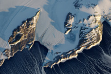
The scene provides a glimpse of the persistent and fierce downslope winds that blow from the interior of the Antarctic ice sheet toward the coast.
Published Nov 10, 2009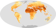
Solid particles and liquid droplets in the air come in a range of sizes, but those smaller than 2.5 micrometers pose the greatest risk to human health.
Published Nov 9, 2010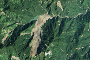
Heavy rainfall from tropical storm Komen triggered a large landslide in Myanmar (Burma).
Published Nov 8, 2015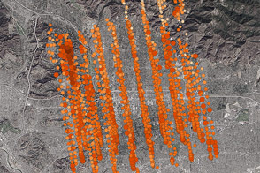
NASA’s new Orbiting Carbon Observatory-2 calibrated its sensors by taking data from an area where ground stations could provide ground truth.
Published Nov 7, 2014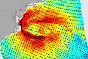
The scenes of devastation and wreckage that these two hurricanes left behind were tragically similar, but the meteorology was very different.
Published Nov 6, 2012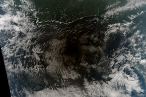
This rare event merged annular and total eclipses. It won't happen again until 2172.
Published Nov 5, 2013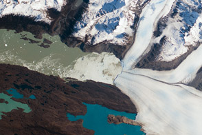
A photograph by an astronaut on the International Space Station shows a progressively shrinking glacier in the North Patagonian Icefield.
Published Nov 4, 2013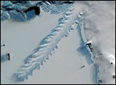
The edge of this Antarctic glacier protrudes from the coast of Ross Island with a long, narrow, jagged sheet of ice.
Published Nov 3, 2004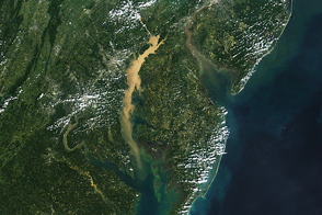
Ships, airplanes, and satellites all play a role in monitoring Chesapeake water quality, algae blooms, and dead zones.
Published Nov 2, 2016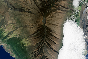
Geologists estimate that Mauna Loa, the world’s largest active volcano, has erupted about once every six years for the past three millennia.
Published Nov 1, 2015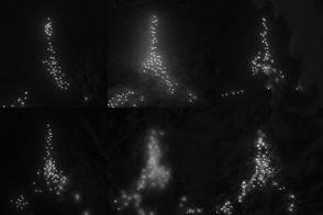
Squid boats create a city of light in the South Atlantic.
Published Oct 31, 2013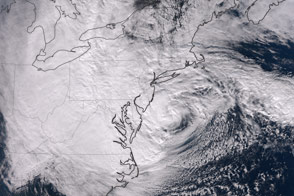
The dramatic late-season storm was observed shortly before making landfall on the U.S. Northeast Coast.
Published Oct 30, 2012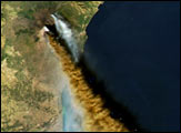
NASA’s Aqua satellite captured this natural-color view of an eruption at Europe’s largest and most active volcano.
Published Oct 29, 2002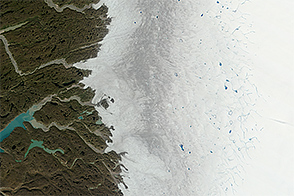
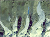
Melting of the Greenland Ice Sheet reveals impurity-rich ice that is thousands of years old.
Published Oct 28, 2014
Flooding submerged large parts of the historic city of Ayutthaya, Thailand, in October 2011.
Published Oct 27, 2011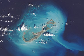
The potent storm spread coraline sediments from the shallows around Bermuda into the deeper ocean.
Published Oct 26, 2014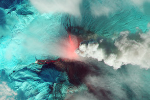
In October 2013, the tallest and most active volcano on Russia’s Kamchatka Peninsula saw a surge in activity.
Published Oct 25, 2013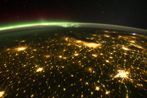
When viewed from the International Space Station, the night skies are illuminated with light from many sources.
Published Oct 24, 2011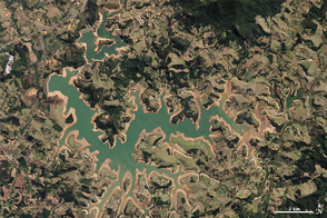
Water supplies are near historically low levels in southeastern Brazil.
Published Oct 23, 2014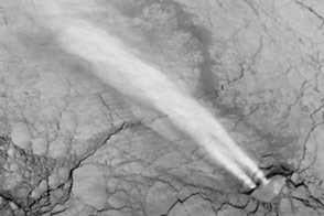
Gas hydrates? Nuclear tests? No. Just unusual, but natural clouds.
Published Oct 22, 2013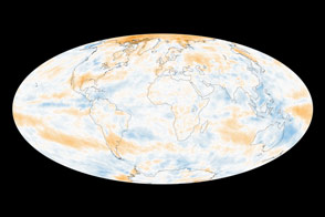
The global picture of how Earth reflects sunlight is a muddle, though several regional trends emerge.
Published Oct 21, 2014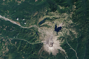
Over 33 years, life has reclaimed the land from the wreckage of the 1980 volcanic eruption.
Published Oct 20, 2013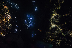
Distinct colors mark the communities and commerce along the Tsushima Strait, between Japan and South Korea.
Published Oct 19, 2014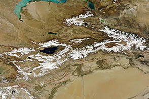
Glaciers on the Tien Shan, a long mountain range that runs through central Asia, serve as a key source of freshwater for cities in the region.
Published Oct 18, 2012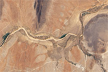
Severe drought gripped much of East Africa in 2009, turning a riverbed into a pale tan ribbon of sand.
Published Oct 17, 2009
Parts of the Glen Canyon that John Wesley Powell explored in 1869 have been submerged by Lake Powell.
Published Oct 16, 2016
Floods and new infrastructure have long since separated the distinctive bend in the river that was portrayed by landscape painter Thomas Cole in 1836.
Published Oct 15, 2017
This image represents, for its time, the greatest detail of the Giza plateau captured from a human-occupied spacecraft.
Published Oct 14, 2001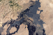
This lava field includes at least 60 flows ranging from 15,000 to 2,100 years old.
Published Oct 13, 2009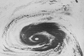
Fifty years ago, NASA launched the first of seven satellites that revolutionized how we study weather, the atmosphere, and other Earth systems.
Published Oct 12, 2014Image of the Day Atmosphere Water Severe Storms Remote Sensing
One of the highest mountain reliefs on Earth can be found in this tiny country sandwiched between eastern India and the Tibetan plateau,
Published Oct 11, 2005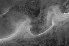
A geomagnetic storm in early October lit up the skies with northern lights that were detected by an Earth-observing satellite.
Published Oct 10, 2012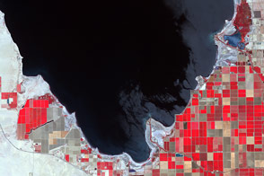
California’s largest lake is shrinking, and an unusual combination of conservation, drought, and water laws may someday take it away.
Published Oct 9, 2015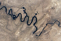
In September 2010, water again flowed through this riverbed after several dry years.
Published Oct 8, 2010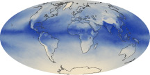
The tiny amount of water vapor in our atmosphere has an outsized influence on the planet as a potent greenhouse gas.
Published Oct 7, 2010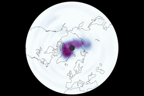
An unusually long period of cold temperatures and strong winds allowed an Arctic ozone hole to form in March 2011.
Published Oct 6, 2011
In September 2002, the collapse of a hanging glacier from Mt. Dzhimarai-Khokh triggered an avalanche that buried small villages in North Ossetia.
Published Oct 5, 2002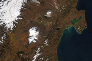
In a span of just 11 days, fall colors swept over the Kamchatka Peninsula in eastern Siberia.
Published Oct 4, 2012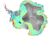
To understand how fast-moving glaciers are changing the ice sheets, scientists devised a method to map elevation change using data from ICESat.
Published Oct 3, 2009
A NASA satellite captures one of its first clear views of the Arctic sea ice cap.
Published Oct 2, 2000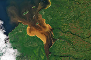
Dissolved organic matter from forests and wetlands stained the water dark brown near Rupert Bay. A similar process darkens tea.
Published Oct 1, 2016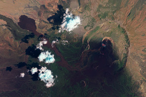
A NASA satellite observed the eruption of a volcano in a remote part of Eritrea.
Published Sep 30, 2011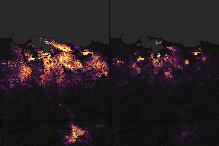
Satellite data on city lights could aid rescue and recovery efforts after Hurricane Maria.
Published Sep 29, 2017Image of the Day Severe Storms Human Presence Remote Sensing
Scientists are using images such as these to locate alteration minerals.
Published Sep 28, 2002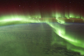
Astronauts on the International Space Station captured these views of the aurora australis and wildfires in Australia.
Published Sep 27, 2011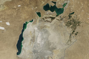
Once part of the fourth-largest lake in the world, the eastern lobe of the southern Aral has dried up for the first time in modern history.
Published Sep 26, 2014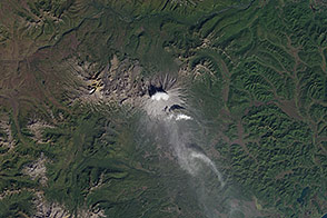
The peninsula has one of the highest concentrations of active volcanoes in the world.
Published Sep 25, 2014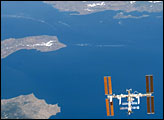
An astronaut shot this photograph while looking back across the length of Endeavour.
Published Sep 24, 2007
In August 2010, Lake Mead reached its lowest level since 1956, the result of a persistent drought and increasing human demand.
Published Sep 23, 2010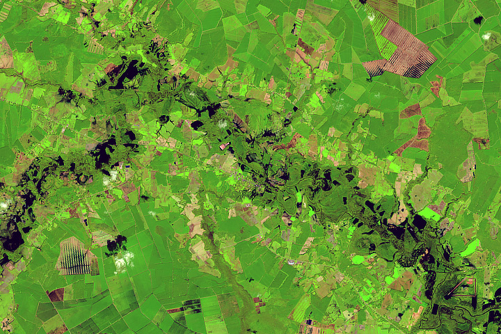
Rivers swelled from the torrential rains of Hurricane Florence.
Published Sep 22, 2018Image of the Day Land Water Severe Storms Human Presence Remote Sensing
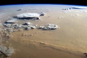
A massive dust storm filled the skies over Libya in early September 2014.
Published Sep 21, 2014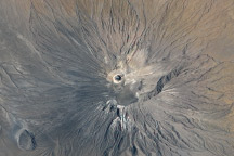
In September 2007, a series of explosive eruptions altered the summit of the volcano, the only one that erupts natrocarbonatite lava.
Published Sep 20, 2009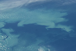
Changing conditions in the waters near Alaska promotes late summer phytoplankton growth.
Published Sep 19, 2014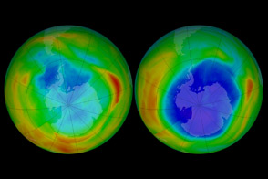
NASA satellites have observed the Antarctic ozone hole since the late 1970s—before and after nations agreed to stop producing chemicals that destroy the ozone layer.
Published Sep 18, 2012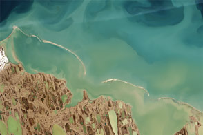
By analyzing satellite images of sediments, coastal researchers and cartographers can identify potential shallows, shoals, and shipping hazards.
Published Sep 17, 2015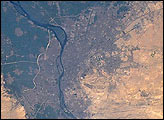
Astronaut photographs from the Gemini era and from the space shuttle reveal tremendous growth.
Published Sep 16, 2001
Rapid growth in several cities along the Pearl River Delta has made a Chinese megacity larger and more populous than any other urban area in the world.
Published Sep 15, 2015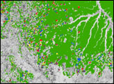
MODIS sensors view the Amazon multiple times a day, so they can provide a rapid assessment of forest change that is not possible with high-resolution sensors.
Published Sep 14, 2005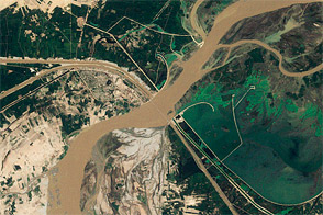
Because the river irrigates millions of acres of farms, the seasonal cycle changes not just the river, but also the surrounding landscape.
Published Sep 13, 2011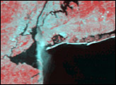
A NASA satellite captured this image of the grim aftermath of the terrorist attacks of September 11, 2001.
Published Sep 12, 2001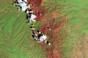
Landsat helps direct restoration efforts in at-risk areas.
Published Sep 11, 2013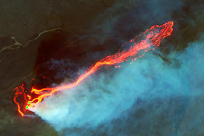
Landsat 8 captured fine details of the lava flowing in Iceland between the Bardarbunga and Askja volcanoes.
Published Sep 10, 2014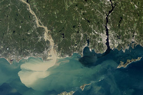
Nearly a week after Hurricane Irene drenched New England, the river was spewing large amounts of muddy sediment into Long Island Sound.
Published Sep 9, 2011
The nation’s problem is also NASA’s problem: Half to two-thirds of our space infrastructure and assets stand within 5 meters of sea level.
Published Sep 8, 2015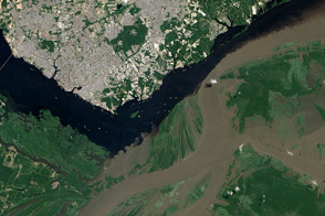
The confluence of the Rio Negro and Rio Solimões in Brazil is famous for unusual mixing patterns.
Published Sep 7, 2012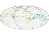
The planet’s wettest areas are getting a little wetter, according to NASA scientists who analyzed 25 years of ground- and space-based rainfall observations.
Published Sep 6, 2007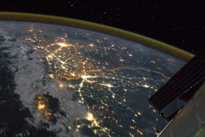
Clusters of yellow lights on the Indo-Gangetic Plain reveal numerous cities large and small, as well as a border fence.
Published Sep 5, 2011
In the past few centuries, a river in northwestern Canada stopped wandering and assumed a more direct route to the sea.
Published Sep 4, 2012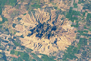
Old volcanic domes form the backbone of the “smallest mountain range in the world.”
Published Sep 3, 2012
An astronaut on the Space Shuttle photographed several wildfires burning in California in August 2001.
Published Sep 2, 2001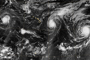
For the first time in recorded history, three Category 4 storms lined up over the central and eastern Pacific Ocean.
Published Sep 1, 2015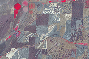
By planting in narrow strips and plowing in patterns that mimic the natural contours of the land, farmers in southeastern Washington are trying to prevent productive soils from washing away.
Published Aug 31, 2014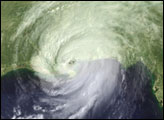
With winds of 135 miles per hour, a powerful storm surge, and heavy rains, the category 4 hurricane pounded the U.S. Gulf Coast, triggering deadly flooding.
Published Aug 30, 2005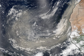
Dust storms in mid-summer 2013 spanned the Atlantic Ocean, depositing particles in the Americas and perhaps suppressing hurricanes.
Published Aug 29, 2013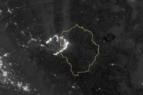
Burning in the northeast corner of Yosemite National Park, the Rim Fire ranks among the largest in California history.
Published Aug 28, 2013
In the first half of the twentieth century, it was the world’s fourth-largest lake. By August 2009, virtually nothing remained of the largest lobe.
Published Aug 27, 2009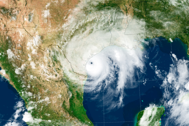
Forecasters believe the storm will be the strongest to make landfall in the United States in 12 years.
Published Aug 26, 2017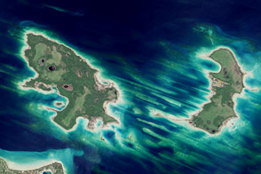
An archipelago in northern Lake Michigan has little in the way of human settlement. However, offshore ridges offer ideal breeding ground for trout.
Published Aug 25, 2013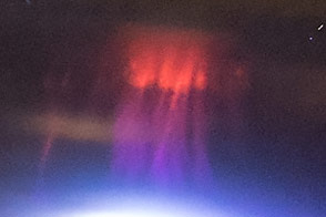
Within three minutes, astronauts acquired two photographs of elusive red sprite emissions above thunderstorms.
Published Aug 24, 2015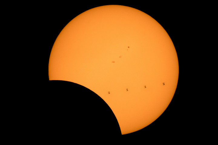
The total solar eclipse proved spectacular whether seen from space, the ground, or mid-flight.
Published Aug 23, 2017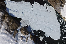
In August 2010, a NASA satellite tracked the chunk of ice as it slowly migrated down the fjord.
Published Aug 22, 2010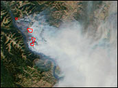
The U.S. Forest Service and National Interagency Fire Center used a new tool to help monitor active wildfires across the entire United States and decide how to best combat them.
Published Aug 21, 2001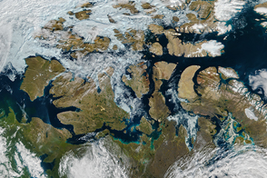
By mid-August 2016, the famed high-latitude sea route in the Arctic Ocean was open.
Published Aug 20, 2016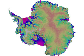
Scientists mapped the motion of Antarctica’s ice sheets and revealed unexpected patterns.
Published Aug 19, 2011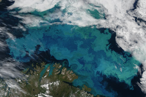
MODIS caught a clear view of an explosion of phytoplankton—a rare treat since the Barents Sea is cloud-covered roughly 80 percent of the summer.
Published Aug 18, 2011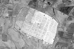
In one year, the refugee camp became the fourth largest population center in Jordan.
Published Aug 17, 2013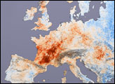
In July 2003, Europe experienced an historic heat wave that killed at least 3,000 people.
Published Aug 16, 2003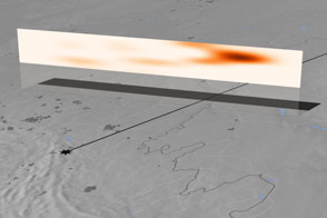
Satellite instruments and computer models help NASA scientists dissect the atmospheric impact of the February 2013 bolide explosion over Russia.
Published Aug 15, 2013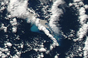
A plume and floating pumice revealed the date and location of the eruption of a remote seamount.
Published Aug 14, 2012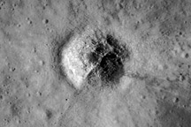
Throughout their histories, both the Moon and Earth have been bombarded by meteorites and asteroids, which often leave behind dramatic impact craters.
Published Aug 13, 2009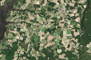
While farms remain a major source of water pollution, signs of improvements are beginning to emerge.
Published Aug 12, 2016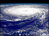
The SeaWiFS instrument captured the data for this composite view of an August 2000 hurricane while it was near Bermuda.
Published Aug 11, 2000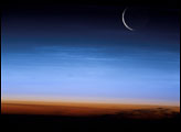
An astronaut on the ISS caught a glimpse of a sliver of the setting Moon and some clouds that shine at night.
Published Aug 10, 2003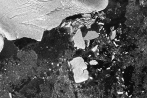
Scientists observed the calving of several large icebergs from the Sulzberger Ice Shelf in Antarctica as a result of the March 2011 tsunami half a world away in Japan.
Published Aug 9, 2011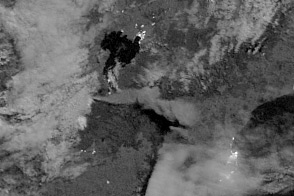
A new satellite captured the eruption of a volcano at night on New Zealand's North Island.
Published Aug 8, 2012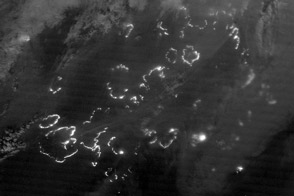
The Suomi NPP satellite carries an instrument so sensitive to low light levels that it can detect wildfires in the middle of the night.
Published Aug 7, 2012
The Deep Space Climate Observatory captured a unique view of the Moon as it passed between the spacecraft and Earth. The Artemis mission will soon take us back for closeups.
Published Aug 6, 2015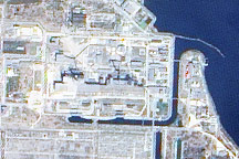
Twenty-three years after the explosion at Reactor Number Four, a NASA satellite glimpsed the remains.
Published Aug 5, 2009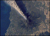
The record of historical volcanism of Mt. Etna is one of the longest in the world, dating back to 1500 BC.
Published Aug 4, 2001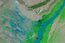
In August 2010, entire villages were washed away, more than 1,100 people died, and an estimated 2.5 million people were affected by dramatic monsoon rains.
Published Aug 3, 2010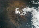
Most scientists agree that the glaciers of Mt. Kilimanjaro will be gone by the year 2020, but there is less agreement as to why they are now receding.
Published Aug 2, 2004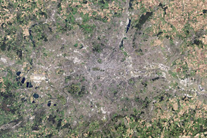
While a typical digital camera takes one picture of a scene based on information from the visible spectrum, Landsat generates multiple views of everything it images.
Published Aug 1, 2012
From orbit around the Moon, the Lunar Reconnaissance Orbiter captured this image of Earth in June 2010.
Published Jul 31, 2010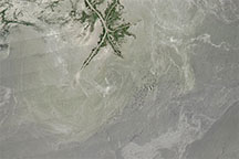
Acquired in the months after the Deepwater Horizon oil spill, this natural-color image shows possible oil patches near the Mississippi Delta.
Published Jul 30, 2010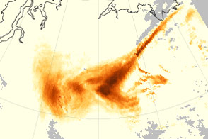
The aerosol index offers a way to see the long reach of forest fires and dust storms.
Published Jul 29, 2014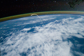
Space Shuttle Atlantis streaked across the sky to its final landing at Kennedy Space Center.
Published Jul 28, 2011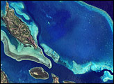
This French-governed archipelago contains the world’s third-largest coral reef structure.
Published Jul 27, 2008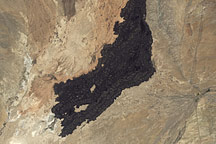
In south-central New Mexico, a charcoal-brown scar undulates across the arid landscape.
Published Jul 26, 2009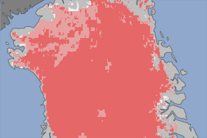
In July 2012, satellites observed melting on nearly 97 percent of the ice sheet surface.
Published Jul 25, 2012
About one third of Earth’s large groundwater basins are being rapidly depleted by human consumption even though we have little accurate data about how much water remains in them.
Published Jul 24, 2015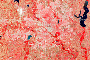
This image of the Dallas metro area was the very first image in the archives of the Landsat mission, launched in 1972.
Published Jul 23, 2012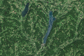
A drop of water that falls in central New York takes a long ride to the sea. It flows past some extraordinary natural features that help tell the story of how the Chesapeake Bay came to be.
Published Jul 22, 2016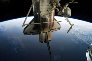
Astronauts supplied the International Space Station with a new logistics module; tested tools, technologies, and techniques to refuel satellites in space; and collected old equipment.
Published Jul 21, 2011
Forty years after the Apollo 11 landing on the Moon, the Lunar Reconnaissance Orbiter captured this image of the descent stage of the Eagle lunar module.
Published Jul 20, 2009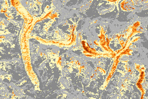
By using satellite sensors that detect infrared radiation, scientists have started to map the mineralogy of debris on glaciers.
Published Jul 19, 2013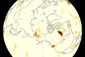
Wildfires in Alaska and Canada send smoke plumes wafting in opposite directions around the Northern Hemisphere.
Published Jul 18, 2015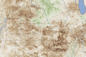
In a dry spell of historic proportions, more than half of the country faced severe or moderate drought.
Published Jul 17, 2012
By launching from the east coast of Florida, NASA took advantage of both geography and physics.
Published Jul 16, 2009
Acquired in 2001 and 2010, these natural-color images show substantial retreat in the Jakobshavn Glacier.
Published Jul 15, 2010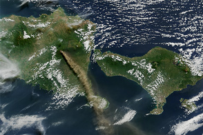
One of the most active volcanoes on the Indonesian island of Java spewed fresh ash and gases in early July 2015.
Published Jul 14, 2015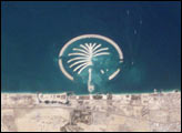
The Islands were constructed on reclaimed land off of Dubai’s Persian Gulf coast.
Published Jul 13, 2003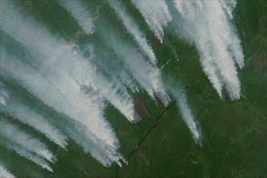
Thick smoke billowed from fires in Yakutia on July 10, 2012.
Published Jul 12, 2012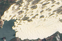
Sand dunes sprawl along the coast of northeastern Brazil, sometimes extending kilometers inland.
Published Jul 11, 2010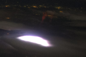
Red sprites, short-lived flashes caused by intense lightning, are rarely captured on camera.
Published Jul 10, 2012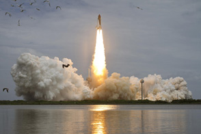
In July 2011, the Space Shuttle Atlantis lit its rockets and roared into space for the 135th and last flight of the U.S. space transportation system.
Published Jul 9, 2011
By providing a measurement of all of the carbon being stored in Earth’s plants, maps like these help scientists figure out what happens to the carbon people release by burning fossil fuels.
Published Jul 8, 2011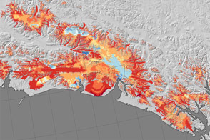
Glaciers in a region of Alaska are losing about 75 billion tons of ice per year, but not all glaciers contribute equally.
Published Jul 7, 2015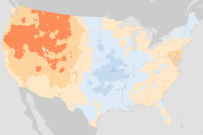
These maps compare January minimum temperatures and July maximum temperatures in the U.S. Climate Normals, a 30-year frame of reference. The new normal reflects a warming world.
Published Jul 6, 2011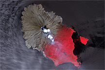
A pair of before-and-after images shows how the June 2009 eruption of Sarychev Peak Volcano transformed Matua Island.
Published Jul 5, 2009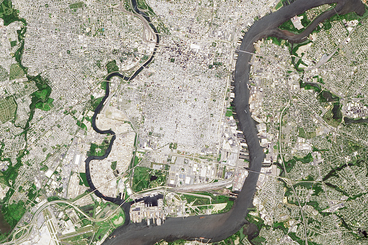
It was here the founders shaped the future of American government.
Published Jul 4, 2017
Modern remote sensing tools are helping to shed new light on the historic battle.
Published Jul 3, 2013
Juba, a port city on the White Nile, is the capital of the new nation of South Sudan and is one of the fastest growing cities in the world.
Published Jul 2, 2012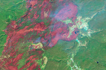
In 1988, wildfires raced through Yellowstone National Park, consuming hundreds of thousands of acres. This series of Landsat images tracks the landscape’s slow recovery through 2008.
Published Jul 1, 2009
This image of Earth is a composite of the first full day of data gathered by the Moderate Resolution Imaging Spectroradiometer on the Terra spacecraft.
Published Jun 30, 2000
On June 26, 2010, oil was visible in the waters surrounding Horn and Petit Bois Islands following the Deepwater Horizon spill.
Published Jun 29, 2010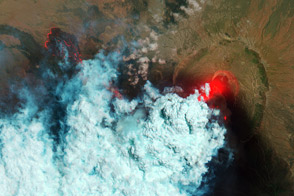
This pair of satellite images was among the first detailed pictures of the erupting vent and lava flows.
Published Jun 28, 2011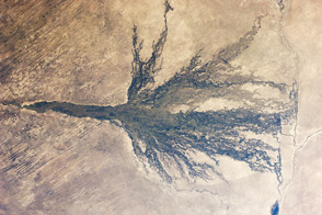
Sometimes called the Jewel of the Kalahari, the area is an enormous, pristine wetland that almost miraculously appears out of a desert.
Published Jun 27, 2011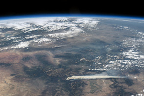
The West Fork Complex fire was so hot that it spawned numerous pyrocumulus clouds.
Published Jun 26, 2013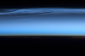
“Night-shining” clouds form at high altitudes in late spring and early summer.
Published Jun 25, 2012
The image shows the tops of the thunderheads with their characteristic anvil clouds.
Published Jun 24, 2003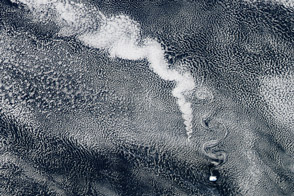
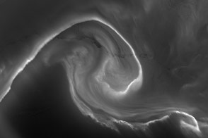
An image from the remote South Sandwich Islands shows how volcanic emissions can create clouds, while the islands themselves deform those clouds.
Published Jun 23, 2012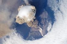
A fortuitous orbit of the International Space Station in 2009 offered the astronauts a striking view of the volcano in an early stage of eruption.
Published Jun 22, 2009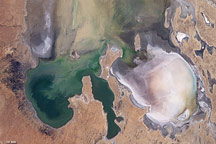
By mid-June 2009, the rare filling of this lake in Australia’s Simpson Desert appeared to have reached its peak.
Published Jun 21, 2009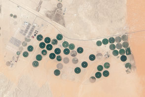
Satellites can help farmers make the most of the limited water resources at a farm in the Arabian Desert.
Published Jun 20, 2015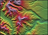
This depiction of an area south of San Martin de Los Andes, Argentina, was the first Shuttle Radar Topography Mission view of the tallest mountain chain in the western hemisphere.
Published Jun 19, 2001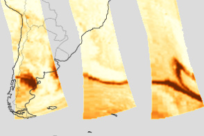
This series of images tracks ash from a Chilean volcano that made a nearly complete circle around the world.
Published Jun 18, 2011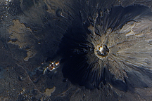
The volcano was almost continuously active from the 1500s until 1760.
Published Jun 17, 2009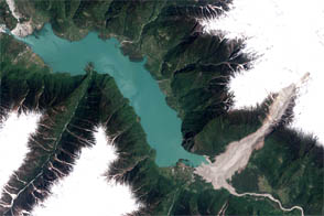
A landslide in eastern Tibet backed up the Yigong River for two months.
Published Jun 16, 2012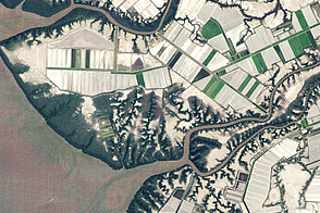
Aquaculture along the coast of the Gulf of Fonseca shows the delicate balance between coastal development and conservation.
Published Jun 15, 2012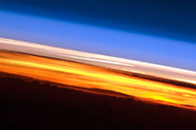
Astronauts aboard the ISS see sixteen sunrises and sunsets per day.
Published Jun 14, 2010
Kilauea erupted enough lava to fill 45,000 Olympic-sized swimming pools.
Published Jun 13, 2018Image of the Day Land Water Volcanoes Human Presence Remote Sensing
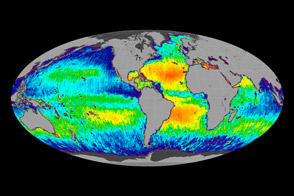
One year after its launch, the Aquarius instrument is giving ocean sciences its first global view of sea surface salinity.
Published Jun 12, 2012
When the Landsat archive is combined with modern computing power, scientists can view the planet not just across space, but also time.
Published Jun 11, 2013Image of the Day Land Unique Imagery Human Presence Remote Sensing
High, cold clouds radiate less thermal energy to space than low, warm clouds.
Published Jun 10, 2010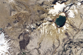
It was the largest eruption of the 20th century, but you've probably never heard of it.
Published Jun 9, 2012
Kaufman served as program manager for NASA’s Earth Observatory from its launch in April 1999, through January 2006.
Published Jun 8, 2006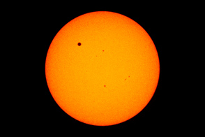
For the first time in history, and the last time for a century, astronauts captured images of the planetary transit as viewed from orbit.
Published Jun 7, 2012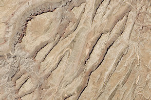
Sinking blocks of rock created this distinctive network of valleys.
Published Jun 6, 2014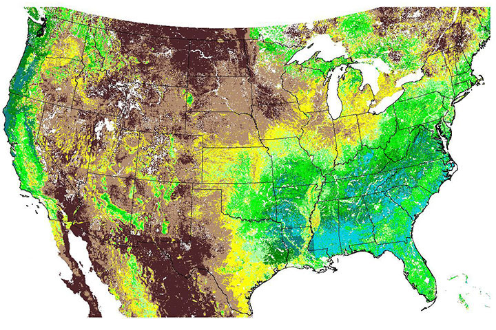
This map of plant photosynthesis was the first of its kind from the MODIS instrument, which was launched in December 1999 on the Terra spacecraft.
Published Jun 5, 2000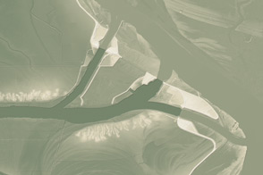
This model of the land elevation between the Mississippi, the Atchafalaya, and the Old River show the uphill fight to control river flow.
Published Jun 4, 2011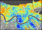
In the three-year period prior to Hurricane Katrina, the city subsided 8 millimeters per year relative to global mean sea level.
Published Jun 3, 2006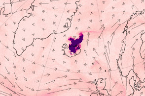
A NASA satellite caught this glimpse of a plume rising and drifting from the Icelandic volcano in May 2011.
Published Jun 2, 2011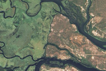
Originating in swampy wetlands, the river tumbles over one of the world’s largest waterfalls, flows through deep gorges, and spreads across broad floodplains.
Published Jun 1, 2010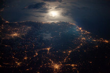
Moonglint and the lights of Torino, Lyon, and Marseille glitter in this nighttime astronaut photo of the Italy-France border region.
Published May 31, 2010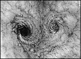
Clouds off the Chilean coast show a unique pattern called a “von Karman vortex street.”
Published May 30, 2000
These images show changes in the landscape before and after an earthquake struck on May 12, 2008.
Published May 29, 2008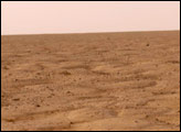
This pair of images shows the similarities between the surface of Mars and permafrost near Spitsbergen, Svalbard.
Published May 28, 2008
The area east of Santa Cruz was originally dry tropical forest.
Published May 27, 2001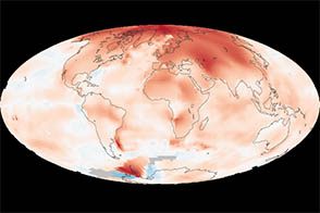
Temperatures are warming faster in the Arctic than anywhere else in the world. Here’s why.
Published May 26, 2013
A satellite records a vertical profile of the atmosphere and reveals the altitude of ash clouds.
Published May 25, 2010
One of LDCM’s sensors can detect faint cirrus clouds that can slightly alter a scene.
Published May 24, 2013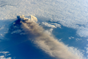
Three striking photographs of Pavlof Volcano reveal the three-dimensional structure of the eruption plume.
Published May 23, 2013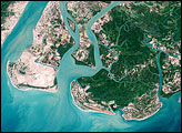
The clearing of the natural mangrove forests has left low-lying cropland and villages exposed to the sea.
Published May 22, 2008
Man and nature have both altered the course of a southwestern U.S. river.
Published May 21, 2012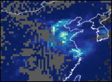
In an effort to control smog during the 2008 Olympics, Beijing officials instituted a number of pollution-curbing measures.
Published May 20, 2007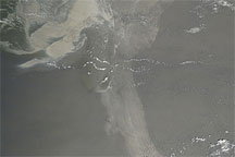
Acquired May 17, 2010, this natural-color image shows the oil slick in the Gulf of Mexico extending a long arm toward the southeast.
Published May 19, 2010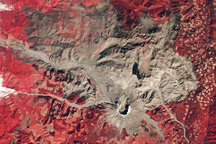
A trio of images documents the devastation and recovery of the landscape around Mt. St. Helens Volcano following its cataclysmic 1980 eruption.
Published May 18, 2010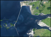
Satellite imagery illustrates the beginning of a land reclamation project that will transform one of the largest tidal estuaries along the Yellow Sea into farmland and a fresh-water reservoir.
Published May 17, 2007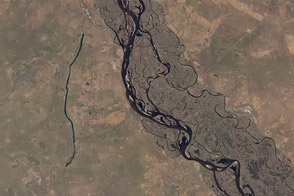
Fifty-six images were stitched together to present a seamless mosaic of what the newest Landsat saw on April 19, 2013. Here are some highlights of the satellite tour.
Published May 16, 2013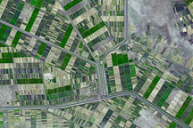
South of Khartoum, where the White and Blue Nile Rivers join, a dizzying arrangement of irrigated fields stretches out across the land.
Published May 15, 2008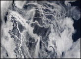
In recent years, scientists have turned their attention to the ways in which human-produced aerosol pollution modifies clouds.
Published May 14, 2002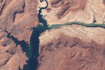
In the early twenty-first century, Lake Powell faced the combined threats of drought and rapid water withdrawals.
Published May 13, 2009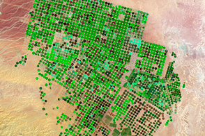
Over the course of 25 years, farms have sprouted in the Arabian Desert, fueled by deep and old groundwater.
Published May 12, 2012
On May 9, 2000, the Landsat 7 satellite acquired an image of the area around Los Alamos, New Mexico.
Published May 11, 2000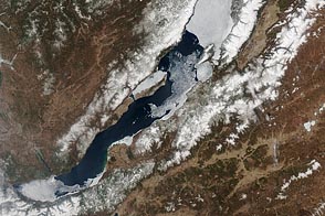
People and satellites keep an eye on when ice on the world’s deepest lake melts each year.
Published May 10, 2012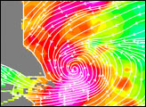
Storms like Typhoon Vamei are not supposed to happen.
Published May 9, 2003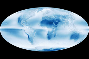
Data collected by a sensor on the Aqua satellite reveals the global distribution of clouds.
Published May 8, 2015
This offshoot of the Circumpolar Current carries cool water north along the coast of South America until it encounters water pouring out of the Rio de la Plata.
Published May 7, 2005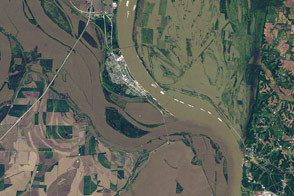
Floods blanket farmland around the confluence of the Ohio and Mississippi Rivers in this Landsat image from May 3, 2011.
Published May 6, 2011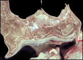
The sequence of images shows the dramatic changes to the Aral Sea between 1973 and 2000.
Published May 5, 2001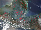
Smoke from fires in tropical Mexico and Central America drifted over the U.S. Gulf States.
Published May 4, 2002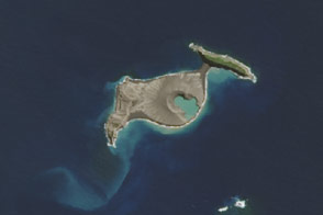
The eruption of an undersea volcano gave rise to new real estate between two islands in the kingdom of Tonga.
Published May 3, 2015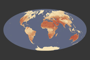
The Sun heats not only the air around us, but the land we walk on. Scientists are interested in the difference between the two.
Published May 2, 2012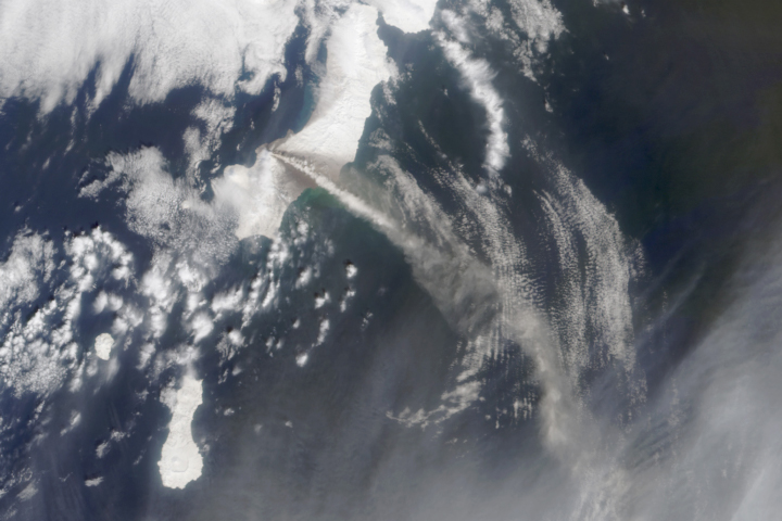
Early data from the MISR instrument helps decipher the dynamics of the gas and ash emerging from a volcano.
Published May 1, 2003