
Skiers and ski resort operators love snow. But it is possible to get too much of a good thing.
Since the beginning of December 2017, many locations in the Alps have been buried by regular, heavy snowfall. Over the same period, much of Western Europe has endured record warmth, prodigious rainfall, and several severe wind storms.
On January 29, 2018, the Moderate Resolution Imaging Spectroradiometer (MODIS) on NASA’s Terra satellite acquired these images of snow cover and low clouds around the Alps. The first image uses natural color, while the second uses a combination of visible and shortwave infrared light (bands 7-2-1) to distinguish clouds and fog in the foothills from the snow and ice cover on the peaks.
According to news reports, road and rail transportation to ski villages in the Alps has been cut off several times this winter due to heavy snow accumulation and avalanches. Near the villages of Zermatt and Andermatt, Switzerland, as much as 10 feet of snow fell in seven days and the base layer of snow is reportedly 200 inches. Near Tignes, France, 17 feet of snow has fallen since the beginning of December. The avalanche threat level in the region has been raised to five, the highest level, several times.
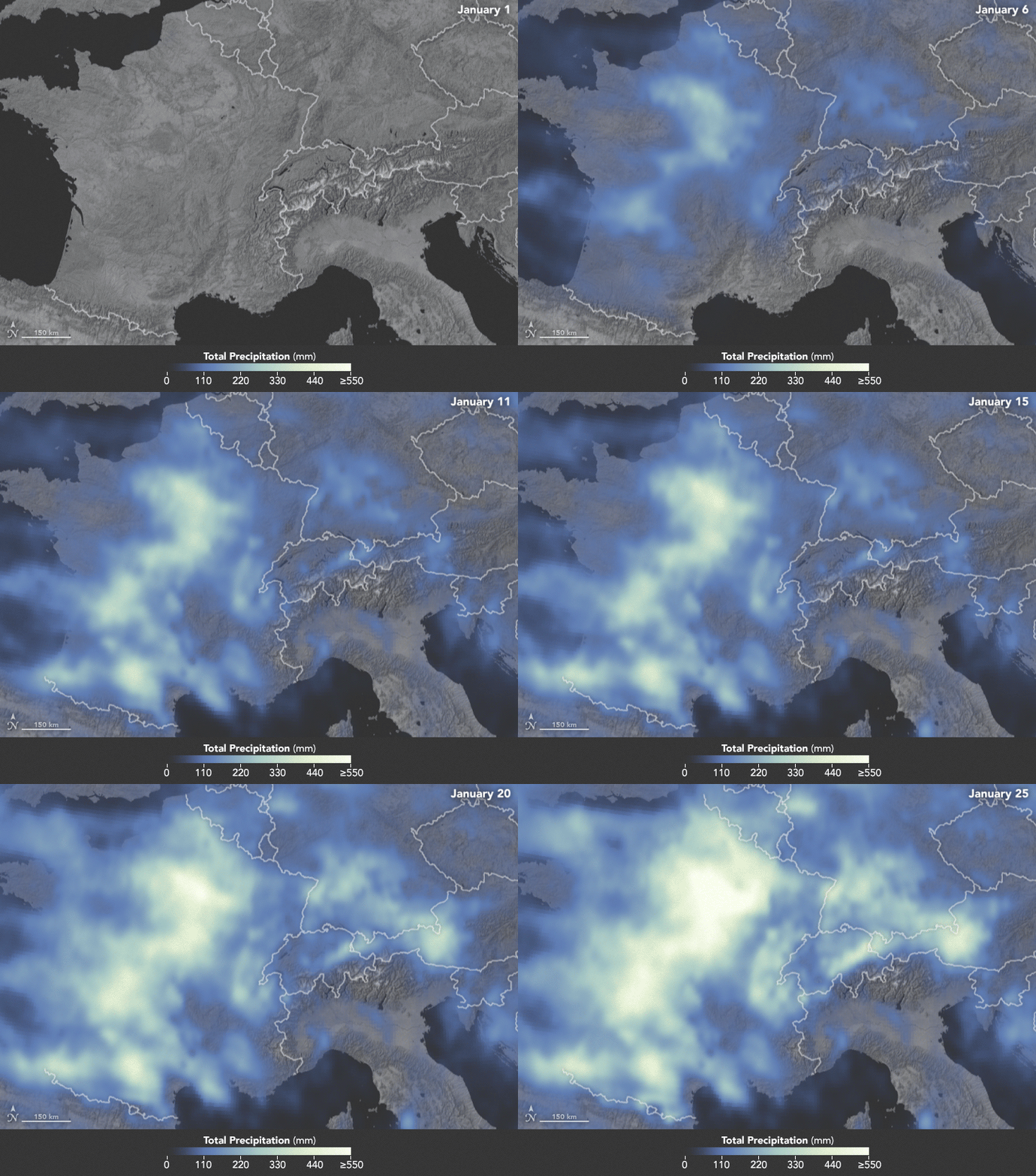
The animation below depicts satellite-based measurements of precipitation in Western Europe from January 1 to 25, 2018. The brightest areas reflect the highest precipitation amounts. The measurements are a product of the Global Precipitation Measurement (GPM) mission, which is a partnership between NASA, the Japan Aerospace Exploration Agency, and five other national and international partners.

These precipitation totals are regional, remotely-sensed estimates of precipitation (liquid and frozen mix); they do not reflect pure snowfall. Each pixel shows 0.1 degrees of the globe (about 7 miles at the equator), and the data are averaged across each pixel. Individual ground-based measurements within a pixel can be significantly higher or lower than the average.
In addition to the snowfall in the mountains, rainfall has been frequent and severe in the lowlands, particularly in France. The Seine River crested at nearly 6 meters (20 feet) in Paris in late January. The warm winter in Europe also means that a fair bit of snow has been melting off and running downstream, even as fresh snow is piling up in the hills.
NASA Earth Observatory images by Joshua Stevens, using MODIS data from LANCE/EOSDIS Rapid Response and IMERG data from the Global Precipitation Mission (GPM) at NASA/GSFC. Caption by Mike Carlowicz.