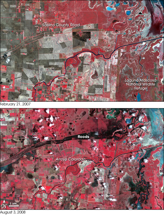


Hurricane Dolly caused flooding in southernmost Texas when it came ashore over the southern end of South Padre Island and Laguna Madre on July 23, 2008. This pair of false-color images of the area from the Advanced Spaceborne Thermal Emission and Reflection Radiometer (ASTER) on NASA’s Terra satellite is a before-and-after comparison of the area northeast of the town of Rio Hondo, Texas.
The image uses visible and infrared light to highlight the presence of water, which is dark blue (clear or deep water) to bright blue (shallow or muddy water). Vegetation appears red, and naturally bare ground (such as fallow agricultural area) is shades of brown. Roads appear as thin beige lines. The Arroyo Colorado flows left to right through the scene. At upper right is the inland edge of Laguna Madre.
Floods are most obvious in two locations: Laguna Atascosa National Wildlife Refuge (lower right) and south of Sabino County Road. Although Arroyo Colorado rose into the trees along its banks during the peak of the flooding, it was not visibly flooded when ASTER captured the after image, on August 3, 2008. According to the National Weather Service, Dolly delivered torrential rains to this and nearby areas, “bringing monthly rain totals in some cases to at least three times average and shattering all-time July records in the Lower Rio Grande Valley.”
NASA image created by Jesse Allen, using data provided courtesy of NASA/GSFC/METI/ERSDAC/JAROS, and U.S./Japan ASTER Science Team. Caption by Rebecca Lindsey.