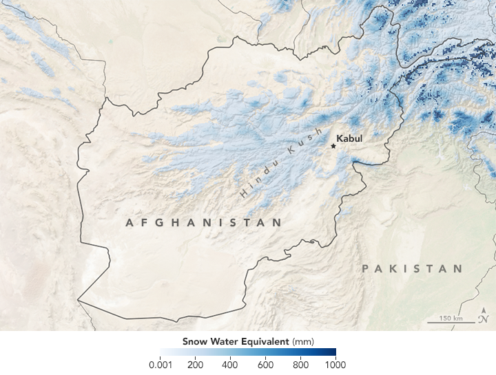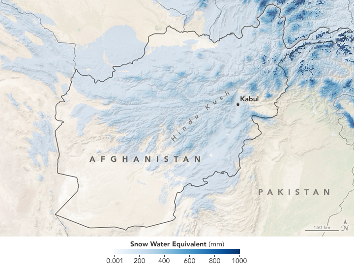


In early February 2017, deadly avalanches buried villages in Afghanistan and Pakistan, according to news reports. Snow is not unusual in these countries; there are even glaciers on some of the highest peaks. What is unusual is the amount and extent of the snow. That’s a concern not only for avalanches this winter, but for potential flooding and crop damage when it melts.
These maps show the snow water equivalent (SWE)—the depth of water that would result if the snow were to completely melt—on February 6, 2017 (second map) and February 6, 2016. The darkest blue areas indicate where the snow contained the most water. Turn on the image comparison tool to see the difference between the years. The biggest change appears to be in the foothills of the Hindu Kush mountain range.
Snow water equivalent is calculated by multiplying the snow’s depth by its density. But it’s not always possible to make direct measurements, particularly in remote regions or across large areas. Instead, these maps are the result of a NASA model that simulates snow conditions. It works by combining remotely sensed estimates of precipitation, temperature, radiation, and wind with information about elevation and topography to determine if, when, and how much snow is present. The model also can simulate the snow depth and snow area, which the scientists compare with satellite images captured by the Moderate Resolution Imaging Spectroradiometer (MODIS).
“Snow water equivalent is a useful variable because it allows us to calculate total water volume in a basin,” said Amy McNally, a researcher with the Land Information System at NASA’s Goddard Space Flight Center. “Decisionmakers find this to be the most useful because it can be used to infer where there might be flooding when snow melts, and how much water can be expected to provide for irrigation during the growing season.”
The maps above show a difference from one year to the next, but how unusual was the snowfall? That depends on the river basin. The modeled data are used by the USGS Earth Resources Observation and Science Center to examine how snow water volume in 18 of Afghanistan’s river basins deviates from the previous year and from the 2001–2015 average. The time series shows that indeed, most basins were above average on February 6, 2017. An anomaly map shows the big-picture differences from the 2002-2014 average.
These data are also used by meteorologists at the NOAA Climate Prediction Center to summarize international weather and natural hazard conditions. The conditions are reported during a weekly webinar with people who study climate and its effect on agriculture (agroclimatologists) and with food security analysts with USAID’s Famine Early Warning Systems Network.
“The availability and access to food are both dimensions of food security,” McNally said. “Weather and water resource information from models and remote sensing can inform questions regarding water availability for crops; hazards like avalanches, or floods that may limit access to food.”
NASA Earth Observatory maps by Joshua Stevens, using land-surface model (LSM) data courtesy of Amy McNally, Jossy Jacob, and the NASA Land Information System. Caption by Kathryn Hansen.