

About halfway down the Aleutian Island chain, tiny Bogoslof Island rises from the Bering Sea. Nobody lives there; the larger Unalaska and Umnak islands to the south have proven more favorable for human settlement. But when Bogoslof erupts, scientists and aircraft pilots take note.
“Bogoslof is just so off the grid, so to speak,” said Erik Klemetti, a volcanologist at Denison University and author of the Eruptions blog at Wired magazine. “However, it ends up being important to know what it’s doing for the sake of flights over the Aleutians.”
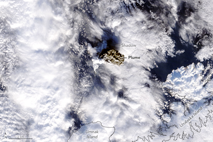
Because the Alaskan island is so remote, scientists monitor the eruptions from a distance by satellite and seismologic data. At 11:35 a.m. local time (22:35 Universal Time) on January 18, 2017, the Moderate Resolution Imaging Spectroradiometer (MODIS) on NASA’s Terra satellite captured this image of a plume rising from the volcano.
Much of the volcano is under water; the tallest parts reach about 150 meters (500 feet) above sea level and span just a few pixels in this image. “Submarine eruptions in the Aleutian arc are rare,” said Chris Waythomas, a geophysicist at the Alaska Volcano Observatory (AVO). “This is the first submarine eruption AVO has been able to monitor with a combination of instruments and techniques—seismic, infrasound, satellite, lightning—so it’s definitely something new for us.”
Note how the plume appears to be two colors. The lower part is white and composed primarily of steam and water vapor. Because the vent has been under water for most of the eruption, its plume contains more water vapor than a plume from a typical terrestrial volcano in Alaska. The upper part of the plume is dark gray-brown and rich in ash. According to Waythomas, “this is the first significant ash-rich volcanic cloud observed during the Bogoslof eruption.”
The presence of an ash cloud has led scientists to speculate that the vent might now be above sea level, but there is no direct evidence. Still, the island is changing shape with every large eruptive event. Thermal data (not pictured) show high temperatures for the first time, a clue that lava might be finding its way to the surface above the water line.
NASA image by Jeff Schmaltz, LANCE/EOSDIS Rapid Response. Caption by Kathryn Hansen.