

Africa’s coastal country of Guinea is nicknamed the “water tower of Africa,” thanks to the more than 20 rivers originating inside its borders, as well as its relatively high precipitation. Mangroves line much of Guinea’s coast, but a 2008 report issued by the United Nations Environment Programme (UNEP) outlined growing pressure placed on these forests by the local population, especially after an influx of refugees from Liberia and Sierre Leone in the 1990s.
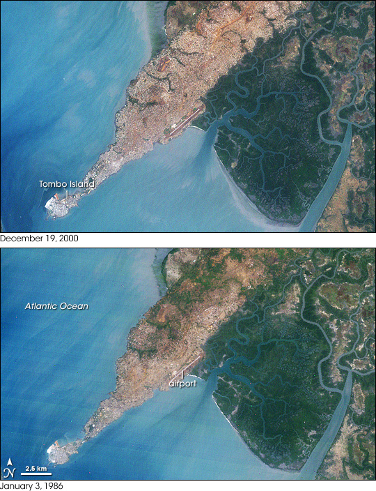
The city of Conakry, Guinea, originated on Tombo Island and spread up the Kaloum Peninsula, sandwiched between mangrove swamps. In the 1960s, the city had a population of fewer than 40,000; in 2006, it had a population of nearly 2 million. These natural-color images, acquired by NASA’s Landsat satellites, show the city’s dramatic growth from 1986 to 2000. Land and water features look similar to how they would look in a photograph by a digital camera. Water ranges in color from deep to pale blue, vegetation appears dark green, and bare ground and urbanized areas range in color from gray to beige to reddish-brown.
In the bottom image, acquired on January 3, 1986, the urbanized area stretches from Tombo Island past Conakry International Airport, yet vegetation remains on much of the peninsula. Urbanization concentrates on the southeastern side of the peninsula as fingers of vegetation wriggle inland from the northwest. In the top image, acquired on December 19, 2000, the fingers of vegetation have thinned to nearly nothing, and the city has spread all the way up the peninsula. Mangroves persist on either side of the city, but according to UNEP, the mangroves were being cleared for agriculture and harvested for firewood.
Besides reporting growing urbanization, UNEP also reported Guinea’s progress in environmental sustainability. Between 1990 and 2005, the proportion of protected land area increased, as did access to improved sources of drinking water and sanitation. Per capita carbon dioxide emissions and the percentage of urban dwellers living in slums decreased during the same period.
NASA image created by Jesse Allen, using Landsat data provided by the United States Geological Survey. Caption by Michon Scott.