

In the wake of the May 12, 2008, earthquake in China, a series of landslides blocked the Jiangjiang River, creating swollen reservoirs that threatened to break through and flood catastrophically. The largest of these lakes, Tangjiashan Lake, threatened roughly 1.3 million people. Chinese authorities faced a dilemma. If they allowed the water to keep rising, it would eventually overtop the dam and flood downstream communities. But cutting a drainage channel through the dam was also risky. The channel could destabilize the dam, and the lake could empty uncontrollably in a wall of water.
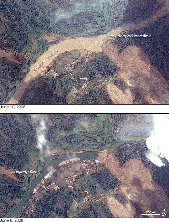
On June 10, 2008, Chinese authorities announced that the landslide that created Tangjiashan Lake had been successfully breached, and the lake had safely drained. These natural-color images, acquired by Taiwan’s Formosat-2 satellite, show changes in the Jiangjiang River—downstream from the lake—before and after the intervention.
The bottom image, from June 8, 2008, shows the apparently slow-moving river, hampered by landslides both up- and downstream (river direction is from left to right). A landslide appears in this scene, and a small sluice (thin, off-white line) appears to have been cut across it to allow water to pass. Some water flows through the river channel downstream.
The top image, from June 10, 2008, shows a swollen, faster-flowing river after the massive landslide upstream was breached. Compared to the image taken two days earlier, the river is wider, and it has submerged some land features along its banks. Its tan hue indicates that it carries considerable sediment, including sediment from the breached landslide upstream. The flooded river has overtopped the smaller landslide shown in this scene.
Draining Tangjiashan Lake was expected to cause a flood wave downstream, and there was a risk that this flood wave could cause substantial damage, including additional landslides. On June 10, 2008, China’s Xinhua news agency reported that the flood wave safely passed through the city of Mianyang, which lies far downstream from the drained lake (see river map) and downstream from the area pictured here.
Draining the lake sent floodwaters coursing into the city of Beichuan, which had been home to some 22,000 people before the earthquake struck. Having already experienced massive damages from the quake, the city was evacuated before authorities drained the lake on June 10. As of June 10, 2008, more than 69,000 people had died in the Sichuan earthquake, and more than 17,000 remained missing.
Formosat image © 2008 Dr. Cheng-Chien Liu, National Cheng-Kung University, and Dr. An-Ming Wu, National Space Organization, Taiwan. Caption by Michon Scott.