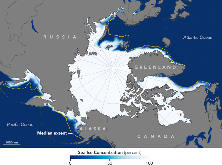


The cap of sea ice over the Arctic Ocean is always changing. Each winter it grows dramatically, usually reaching its maximum in March. It melts just as dramatically each summer, reaching its minimum in September. In 2015-16, that winter growth got off to a leisurely start due in part to a month of unusually warm weather in the region. Sea ice extent for January 2016 was among the lowest since space-based observations began in 1978.
The map above shows Arctic sea ice extent for January 2016. The yellow outline shows the median sea ice extent observed in January from 1981 through 2010, as determined from a sequence of NASA and U.S. Department of Defense satellites. With the exception of the yellow line, the map was compiled from observations by the Advanced Microwave Scanning Radiometer 2 (AMSR-2) sensor on the Global Change Observation Mission 1st–Water (“Shizuku”) satellite, which is operated by the Japan Aerospace Exploration Agency (JAXA).
A preliminary analysis released by the National Snow & Ice Data Center found that Arctic sea ice extent averaged 13.53 million square kilometers (5.2 million square miles) during January 2016—1.04 million square kilometers (402,000 square miles) below the 1981 to 2010 average.
“The low ice coverage in the Arctic in January 2016 continues the overall trend toward lessened Arctic sea ice that has been apparent from the satellite data for decades now,” said Claire Parkinson, a climate scientist at NASA’s Goddard Space Flight Center. “Since the late 1970s, the Arctic sea ice extent has experienced considerable variability from year to year but also a strong overall downward trend. This is true for every month of the year, as well as for seasonal and annual averages.”
The low extent in 2016 included unusually low ice coverage in the Barents Sea, Kara Sea, and the East Greenland Sea on the Atlantic side, and below average conditions in the Bering Sea and Sea of Okhotsk. Ice conditions were near average in Baffin Bay, the Labrador Sea and Hudson Bay. There was also less ice than usual in the Gulf of St. Lawrence.
A shift in the Arctic Oscillation likely weakened the atmospheric barrier between the polar latitudes and the mid-latitudes. This brought unusually high temperatures to the Arctic in January. Storms arriving from mid-latitudes brought additional heat and prevented ice growth.
While climate scientists expect sea ice to continue to decline in the coming decades due to global warming, there will still be plenty of variability from month to month and year to year.
NASA Earth Observatory maps by Jesse Allen, using data from the Advanced Microwave Scanning Radiometer 2 (AMSR2) sensor on the Global Change Observation Mission 1st-Water (GCOM-W1) satellite. Caption by Adam Voiland, based on materials provided by the National Snow & Ice Data Center.