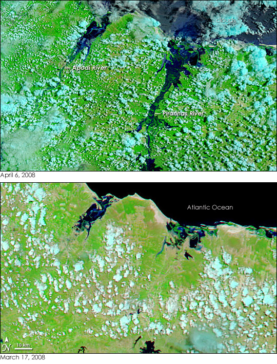


The swollen Piranhas and Apodi Rivers, barely visible in satellite images from mid-March 2008, flow dark blue over the bright green, plant-covered landscape of northeastern Brazil in early April 2008. The two rivers were among many that overflowed in this normally dry corner of Brazil in the wake of heavy rains in March and April. Six states, including Rio Grande do Norte, shown here, flooded. As of April 7, the floods and mudslides had killed 21 people and forced 82,000 from their homes, reported the Associated Press.
Although clouds hide much of the flooding in the state on April 6, 2008 (top image), the Piranhas and the Apodi Rivers were clearly much wider than they had been on March 17 (lower image) before the rains began. These images were captured by the Moderate Resolution Imaging Spectroradiometer (MODIS) sensors on NASA’s Terra (April 6) and Aqua (March 17) satellites.
Additional signs of flooding can be seen in the Atlantic Ocean. In this type of satellite image, which is made with both infrared and visible light, water is usually black. Sediment colors the water blue. Though reflected sunlight obscures the color of the ocean in the top image, the underlying tone is blue, hinting at the flood runoff flowing into the ocean. Rainfall is also evident in the plants that cover the land. The landscape went from green and tan, the color of bare earth or sparsely vegetated land, to green as plants responded to the rain. Clouds in this type of image are turquoise and white.
NASA images courtesy the MODIS Rapid Response Team at NASA GSFC, which produces daily images of northeastern Brazil. Caption by Holli Riebeek.