

Unlike Mauritania’s Tenoumer Crater or Australia’s Wolfe Creek Crater, Germany’s Ries Crater (or Nördlinger Ries) is not easily discerned in space-based images. The crater’s existence was probably just as subtle to the medieval Europeans who established a settlement inside it and unknowingly matched their 1-kilometer- (0.6-mile-) wide city to the likely diameter of the meteorite that formed the crater. The city’s church of St. George is composed primarily of blocks of suevite—rock that had earlier been melted by the meteorite impact.
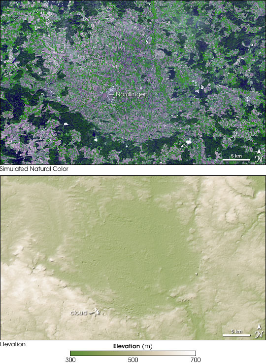
The Advanced Spaceborne Thermal Emission and Reflection Radiometer (ASTER) on NASA’s Terra satellite captured these observations of the Ries Crater on September 7, 2006. The top image is a simulated natural-color picture of the Reis Crater, with the city of Nördlingen situated near its center. In this image, dark green indicates forest, bright green indicates agriculture, and blue-gray indicates buildings and paved surfaces. The bottom image is a digital elevation map of the area’s topography based on ASTER data acquired in the same overpass. The lowest lying areas are tan-green, the highest areas are off-white, and areas in between are tan. The crater is easier to discern in this image, thanks to its low elevation.
Ries Crater is 26 kilometers (16 miles) in diameter, with a crater rim roughly 200 meters (660 feet) above the crater floor. Unlike Wolfe Crater, it does not have a visible area of central uplift, but it does have an irregular inner ring some 12 kilometers (7.5 miles) wide, sporting hills some 50 meters (165 feet) above the surrounding area.
Nördlinger Ries’s status as an impact crater did not become apparent until the 1960s. Prior to that time, many geologists suspected the crater had been formed by volcanic activity. One line of evidence supporting the impact theory included shocked quartz grains, which are formed by meteorite impacts. Another was the building material used for the church of St. George.
You can download a 15-meter-resolution KMZ file of the crater suitable for use with Google Earth.
NASA image created by Jesse Allen, using data provided courtesy of NASA/GSFC/METI/ERSDAC/JAROS, and U.S./Japan ASTER Science Team. Caption by Michon Scott.