

El Niño has returned to the Pacific Ocean, according to scientists at the National Oceanic and Atmospheric Administration (NOAA), but it is weak and late and not likely to deliver much precipitation to the parched American West.
In an El Niño event, surface waters in the central and eastern Pacific become significantly warmer than average, influencing weather patterns and affecting fisheries along the west coasts of North and South America. The pattern sets up when easterly trade winds in the Pacific falter and allow giant waves of warm water to drift from the western Pacific toward the Americas. NOAA’s Climate Prediction Center recently observed sea surface temperatures about 0.6°C above average in the central, equatorial Pacific, one of the key indicators of El Niño.
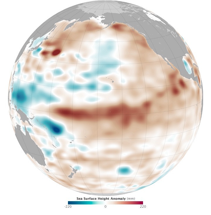
The map above provides NASA’s view of the conditions. It shows the ten-day average of sea surface height (centered on March 13, 2015) in the Pacific Ocean. It is based on data collected by the Ocean Surface Topography Mission/Jason 2 satellite and analyzed by scientists at NASA’s Jet Propulsion Laboratory.
Shades of red indicate where the ocean stands above normal sea level—warmer water expands to fill more volume because of thermal expansion. Shades of blue show where sea level and temperatures are lower than average (thermal contraction). Normal sea-level conditions appear in white. Above-normal sea surface heights in the central and eastern equatorial Pacific indicate El Niño conditions, while below-normal heights there indicate La Niña.
When it is potent, El Niño can have a significant impact on weather and climate far from the tropics. Past events have brought significant snow and rainfall to the Rockies, Sierras, and other mountain ranges in the western U.S.; prompted mild winters in the northeastern U.S.; altered rainfall patterns in the South; and reduced the number (if not the potency) of land-falling hurricanes on the Gulf and Atlantic Coasts. But because of its late arrival—El Niño historically peaks between December and April—and its moderate strength, this year’s event is not expected to have much impact. It might amplify global temperatures, as El Niño years tend to be warmer globally than La Niña or neutral years.
Bill Patzert, a climatologist at JPL, has not been enthused about the current El Niño conditions—he called it “El Wimpo” to a local newspaper—but he suggested that a larger pattern could be shifting. He pointed to a wedge of warm water off of Mexico and a horseshoe-shaped pattern of cooler waters in the western Pacific near Papua-New Guinea and the Philippines. He also noted that several Kelvin waves appear to be marching across the Central Pacific. All three features hint at changes in another Pacific cycle.
For most of the past 15 years, Pacific Ocean conditions have been dominated by a negative phase of the Pacific Decadal Oscillation (PDO), a long-term pattern of variations in sea surface temperatures that scientists are still trying to understand. In the negative phase, temperatures are warmer in the interior of the Pacific and cooler along the North American coast. Negative PDO is often associated with droughts in the American West. In the positive phase, waters grow warmer along the west coast of North America and cooler in the interior of the North Pacific.
The signs have been pointing to a positive PDO. “This sea surface height map is a ‘keep-your-fingers-crossed, there’s-some-hope’ image,” Patzert noted. “That’s not a forecast, but there is a glimmer of hope.” NOAA’s Northwest Fisheries Science Center also recently noted that waters off the West Coast have become warmer and less productive, which could be another sign of a shifting PDO regime.
A major shift in the PDO could accelerate global temperature changes and affect jet stream patterns and regional weather. That could mean more precipitation in the American West and milder winters in the East, but there are no guarantees. There are also a host of negative impacts on eastern Pacific fisheries and marine life.
Patzert adds that neither El Niño nor a positive PDO are the answer to all of the water concerns in the Americas. “El Niño is a temporary blessing or curse,” he said, noting that drought problems are affected by—but not necessarily caused or solved by—a change in the weather. “El Niño can't cure an increasing water demand due to population and economic growth.”
NASA Earth Observatory image by Joshua Stevens, using JASON-2 data provided by Akiko Hayashi and Bill Patzert, NASA/JPL Ocean Topography Team. Caption by Michael Carlowicz.