

“By clearing America of woods,” Benjamin Franklin wrote, Americans were “Scouring our Planet—and so making this Side of our Globe reflect a brighter Light to the Eyes of the Inhabitants of Mars or Venus” (quoted in Williams, M.). However, it was not the inhabitants of Mars or Venus that were likely to be affected by the newly bright land, the prescient weatherman noted, it was the very Americans who were carving farms out of the forest. Franklin and other colonists agreed in 1763 that “cleared land absorbs heat and melts snow quicker,” but Franklin believed that years of observations would be necessary before anyone could make any conclusion about the effect of deforestation on local climate. He was right. In 2008, 245 years later, scientists are just beginning to understand how much land use can change the weather.
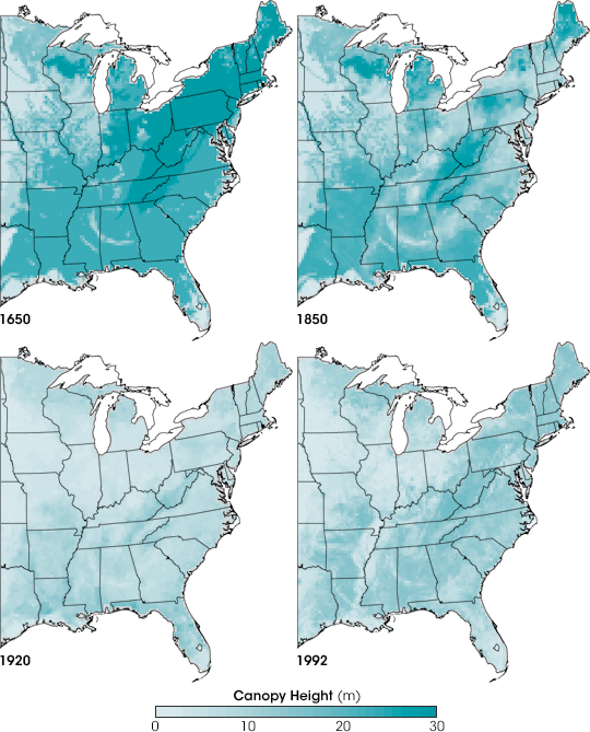
Franklin only saw the beginning of the disappearance of the eastern forest. This series of maps shows how much the landscape of the eastern United States changed between 1650 and 1992. The maps depict canopy height, the height of the tallest continuous layer of vegetation. In 1650, before colonization, most of the eastern United States was covered in tall forest, shown in dark blue-green. During the next 200 years, the forest disappeared, particularly in New England, the mid-Atlantic, and parts of the Midwest. By 1920, the tall forest was entirely gone, replaced by cities and farms. During the latter half of the twentieth century, the forest began to regrow, but the overall canopy remained much shorter than it had been before 1650. The images are based on a reconstruction of land cover made from records ranging from 1850 census data to modern satellite measurements.
Franklin might ask, if Americans transformed the entire eastern forest into farmland, “making this Side of our Globe reflect a brighter light,” how did that large-scale change affect the weather? Plants slow the rush of wind over the land, they respire water vapor and soak up energy and light during photosynthesis, and, as Franklin observed, they reflect light into space. All of these interactions influence local weather patterns, and if you change the character of what is growing on the land by converting a forest to a farm, for instance, you can change weather patterns, too. In order to understand how land use may have changed weather in the eastern United States, scientists run regional climate models. The models simulate the interaction between plants and the atmosphere with numbers that represent biological and physical characteristics of the land cover—called biophysical parameters—such as vegetation height, leaf density and color (its reflectivity), and seasonality.
Biophysical parameters are easy to measure for modern vegetation, but how do scientists know what those characteristics were in the past? Native old-growth vegetation has different characteristics than modern regrowth, particularly in a forest. NASA and USGS scientists Louis Steyaert and Robert Knox combed through both historical and modern records of vegetation to characterize biophysical parameters for 1650, 1850, 1920, and 1992. This series of images shows one of the biophysical parameters (canopy height) they mapped during their five-year project. Published in January 2008, their biophysical parameter maps are now being added to regional climate models to study the impact of land cover change on the climate. To read more about how Steyaert and Knox reconstructed past land cover, see Ancient Forest to Modern City: Mapping Landscape Change in the United States, a feature article on the Earth Observatory.
Maps by Jesse Allen and Robert Simmon, based on data from Steyaert and Knox. Caption by Holli Riebeek.