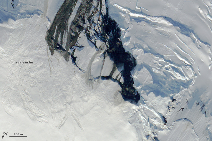


The fortuitous timing of some recent NASA science flights gave scientists a rare opportunity to see what can happen when Earth's polar regions are shaken by an earthquake.
On July 17, 2014, a magnitude-6.0 earthquake struck beneath Seward Glacier in northwestern Canada, 99 kilometers (62 miles) north-northwest of Yakutat, Alaska, according to the Alaska Earthquake Information Center. Meanwhile in Fairbanks, Alaska, NASA glaciologist Kelly Brunt and fellow scientists, engineers, and pilots were gearing up for near-daily flights with an airborne instrument called the Multiple Altimeter Beam Experimental Lidar, or MABEL. The instrument has nothing to do with earthquakes; rather, scientists are using it to develop processes for interpreting data from ICESat-2, a satellite scheduled for launch in 2017.
Next to MABEL in the nose cone of NASA's high-altitude ER-2 aircraft, scientists placed a digital camera. The images from that camera are typically used to visually confirm the type of surface—ice, open water, or melt ponds—being measured by MABEL's laser pulses. The camera came in handy thanks to some lucky timing.
The MABEL team was already scheduled to make two flights near Seward Glacier in late July when a colleague back in Maryland alerted them to the earthquake. Their flight paths were taking them as close as 2 kilometers (1.2 miles) from the epicenter of the earthquake. Flights over the region just before and after the event provided an uncommon view of an earthquake's effect on the snow-and-ice covered landscape.
One effect is apparent in the digital photograph at the top of this page, which was taken on July 16, one day before the quake. Rocks and debris from a previous landslide are littered across the young, steep slopes alongside Seward Glacier. When scientists flew back over the site on July 21 (second image), snow from a large avalanche had cascaded down the mountainside and obscured remnants of the older slide. The third image (below) shows the avalanche in relation to Seward Glacier.
“It's obvious that many big debris and snow slides happened in this short time window,” said Brunt. “This is a super steep area, so you get a lot of activity here. The bulk of the activity in this case is probably associated with the July 17 quake.”
Photos from the MABEL team suggest that the earthquake also might have prompted the draining of a supraglacial lake. The images below from July 16 and 21 show dramatic changes in the amount of melt water pooled on top of the ice adjacent to Seward Glacier. The July 21 photo suggests that much of the lake drained through a moulin, a vertical shaft down through the glacier. Possible moulins appear in the lake's center and to the left of the lake.
When melt water travels through a glacier's plumbing, the ice responds. In this case, it appears to have lifted up and formed a mound in center of the lake. The uplift displaced the remaining water, changing the shape of the shoreline. Brunt cautions that while she is pretty sure the snow avalanches and debris slides can be attributed to the quake, she is less certain about the drainage event. Supraglacial lakes are ephemeral, and they can fill and drain on short timescales even without earthquakes or other dramatic events.
“This was the first time that we successfully used the MABEL camera in the field,” said Brunt. “It is intended for MABEL validation and not necessarily as a scientific instrument in its own right. So we were pleasantly surprised when we were able to use the imagery to make a wicked cool observation of quake-induced change.”
NASA Earth Observatory images created by Jesse Allen, using digital photographs provided by Kelly Brunt, MABEL campaign. Caption by Kathryn Hansen.