

Low-lying, traced by innumerable rivers and streams, and densely populated, Bangladesh is exceptionally vulnerable to floods. Widespread flooding is common during the wet season of the monsoon (June-October), and is even beneficial, as the floods lay down fertile soils. But even a country familiar with regular floods can be devastated by the flooding rains and storm surge of a tropical cyclone.
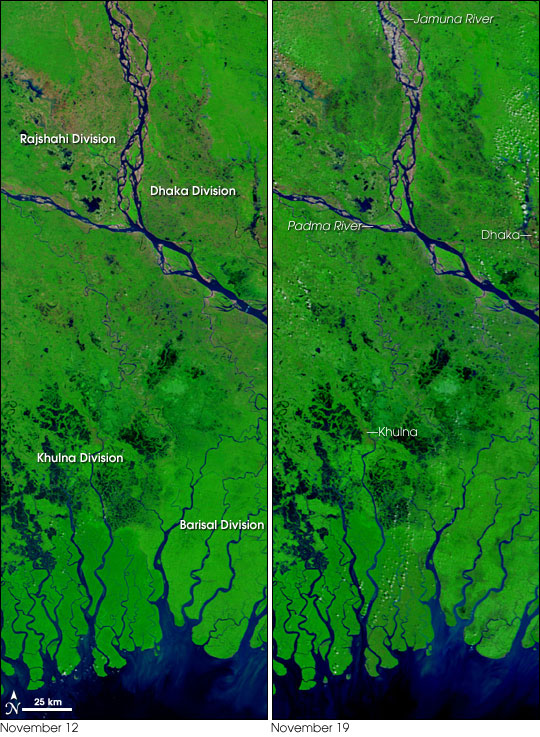
This pair of images from the Moderate Resolution Imaging Spectroradiometer (MODIS) on NASA’s Terra satellite shows a section of Bangladesh before (left) and after (right) the passage of Cyclone Sidr through the country in mid-November 2007. The images are made from a combination of visible and infrared light to make water (dark blue or black) stand out from vegetation (green) and bare ground (pinkish-tan).
On November 12, as the dry season was just getting underway, there was plenty of water still on the ground in places. After the passage of Sidr, however, flood waters filled the countryside in Rajshahi (upper left) and Dhaka (upper right) Divisions on either side of the Jamuna River. Ground that was bare before the cyclone, perhaps newly planted or cleared fields, was water-logged on November 19. The blue of the flood waters mixes with the green vegetation to create a bruised look. This increased “bruising” is also obvious on the peninsulas of the Barisal Division. In Khulna Division, the differences are more subtle, but floods are apparent across the land northwest of the city of Khulna.
According to news reports from the BBC, several thousand people have died in the floods, and officials fear that number will rise in coming weeks. Millions have been made homeless, and aid workers are struggling to reach many locations, some of which are only accessible by small boats.
Sidr brought a huge storm surge and heavy rains. Wildlife biologists are concerned that the storm surge may have devastated habitat and wildlife in Sundarbans National Park, which spans the coastline of southwest Bangladesh and India (not pictured). The park is the largest area of intact mangrove forest in the world and is critical habitat for the endangered Royal Bengal Tiger.
NASA image courtesy the MODIS Rapid Response Team, Goddard Space Flight Center