

Thanks to fires in western Montana and Idaho in August 2007, pollutants traveled eastward across much of the United States, affecting air quality hundreds of miles from the flames. According to the U.S. Air Quality (Smog Blog) at the University of Maryland, Baltimore County, air quality along the U.S. East Coast suffered from the northwestern fires.
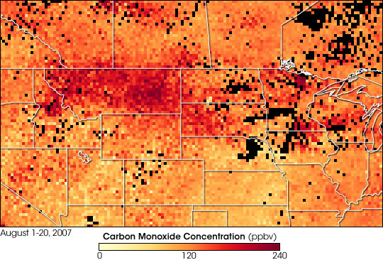
This image tracks the smoke east from Idaho and Montana across North and South Dakota, Minnesota, Iowa, and Wisconsin by showing carbon monoxide concentrations, one component of the smoke, as observed by the Measurements Of Pollution In The Troposphere (MOPITT) instrument aboard NASA’s Terra satellite between August 1 and August 20, 2007. The colors represent the carbon monoxide concentrations in parts per billion by volume at an altitude of approximately 3 kilometers (1.9 miles). Lowest concentrations appear in yellow and highest concentrations appear in red. Black indicates areas where persistent cloud cover prevented thorough measurements.
An arc of high carbon monoxide levels reaches from central Idaho, through Montana, and dips southward across South Dakota. This area matches smoke plumes that were visible across the area in mid-August. Concentrations remain high as far east as the Great Lakes region. Along the top left edge of the image, patches of dark red across Alberta and Saskatchewan are probably also the result of forest fire activity in August.
Fires produce large amounts of carbon monoxide, which remains in the atmosphere for about two months on average. By contrast, the gray particles that make the smoke visible in the air disappear after about a week. Because carbon monoxide stays in the atmosphere so long, scientists can track a plume of smoke much farther by measuring carbon monoxide than by looking for visible signs of the smoke. Compared to the particles, carbon monoxide also acts more like other gaseous pollutants in the smoke that might be hard to measure directly. As a result, measurements of carbon monoxide provide an estimate of how much of these pollutants might have been emitted by the fires. In addition to revealing pollution from a single event, the view of carbon monoxide from space gives remote-sensing scientists a way to trace the global transport of smoke-related pollution.
NASA image created by Jesse Allen, using data provided by the National Center for Atmospheric Research (NCAR) and the University of Toronto MOPITT Teams