

By April 2, 2012, heavy rains had claimed at least three lives in Fiji and sent thousands of people to evacuation centers, news reports said. Heavy rains washed out roads, severed drinking water supplies, downed power lines, and hampered communications.
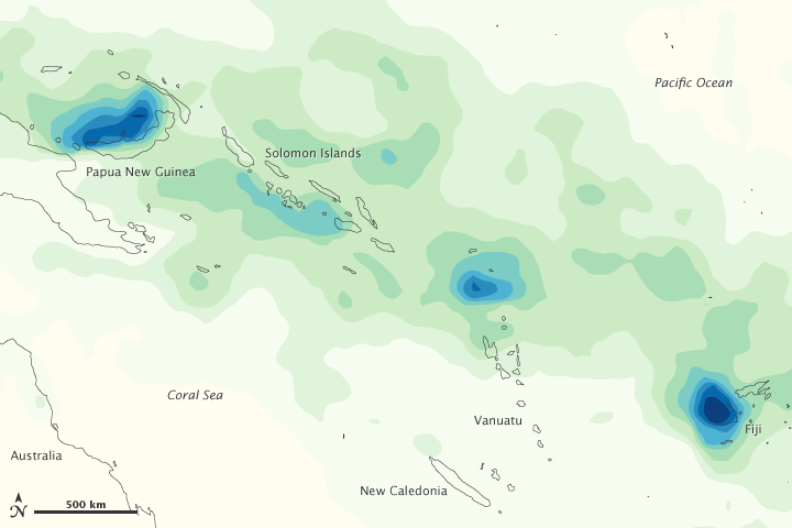
This image shows rainfall totals between Papua New Guinea and Fiji from March 26 to April 2, 2012. The heaviest rainfall—more than 600 millimeters, or 24 inches—appears in dark blue. The lightest rainfall—less than 75 millimeters or 3 inches—appears in light green. Trace amounts appear in pale yellow.
Areas of intense rain occurred within a wide band of precipitation between the Pacific Ocean and the Coral Sea in late March and early April. Although much of the precipitation fell over open ocean, some of the heaviest rain fell on Fiji—in particular, on the large island of Viti Levu.
The rains left homes underwater and led to landslides, including one near a resort and another near a hospital. The government of Fiji requested that airlines stop flying travelers to the country until further notice, and planes began arriving empty at Fiji airports in order to evacuate stranded tourists.
As Fiji coped with floods, Tropical Cyclone Daphne threatened to inundate the islands again. A bulletin from the Fiji Meteorological Service reported that, as of 6:00 p.m. local time on April 2, 2012, Daphne was located roughly 540 kilometers (335 miles) west-southwest of Nadi, a city on the west coast of Viti Levu.
This map is based on data from the Multisatellite Precipitation Analysis produced at NASA’s Goddard Space Flight Center, which estimates rainfall by combining measurements from many satellites and calibrating them using rainfall measurements from the Tropical Rainfall Measuring Mission (TRMM) satellite.
NASA Earth Observatory image by Jesse Allen, using data from the TRMM Science Data and Information System at Goddard Space Flight Center. Caption by Michon Scott.