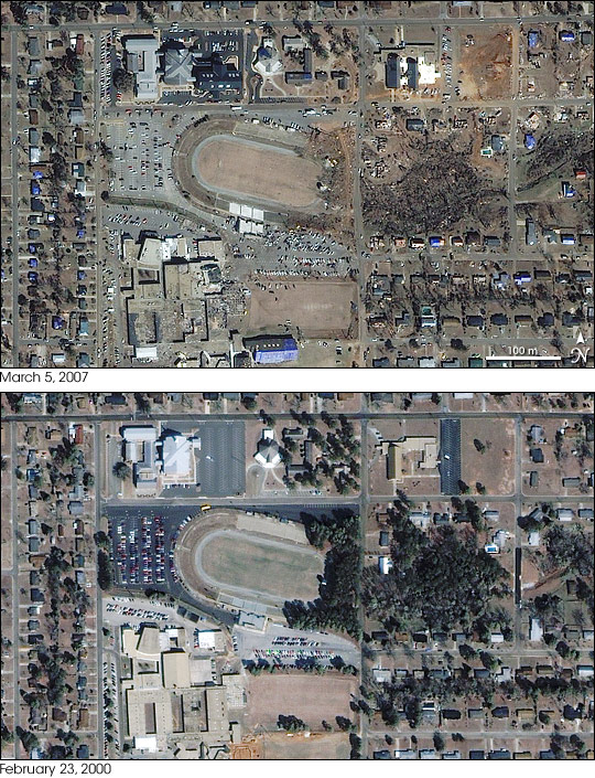


A massive tornado tore through Enterprise, Alabama, on March 1, 2007, leaving a swath of devastation about 180 meters (200 yards) wide through the small city. In the center of the storm’s path was Enterprise High School, where students sheltered in hallways as the tornado struck. The tornado ripped the roof off parts of the school, destroyed a hallway, the gym, and the stadium, said ABC News. By March 2, eight students were confirmed dead.
The Ikonos satellite captured this detailed image of the school on March 5, 2007. The lower image, provided for comparison, shows the school on February 23, 2000. A cluster of rectangular and “U”-shaped buildings make up the main structure of the school in the lower left corner of the image. An outdoor stadium borders the school on the northeast, and a residential area surrounds the school.
The tornado’s track is clearly visible tracing diagonally across the top image from the lower left to the upper right corner. The most damaged building in the image is the high school. The “U”-shaped building on the southwest corner of the school appears to have partially collapsed, and the remaining section of the building is missing its roof. Debris clutters the area around the school, giving the block a messy appearance. The tornado also swept across the eastern edge of the stadium. The trees that fringed the edge of the stadium in 2000 are gone. The houses or small businesses across the street from the stadium have also been destroyed, and many of the trees on the formerly wooded block appear to be missing. Across the street to the north, a raw muddy field replaces the grassy lot that formerly stood on the site. In the large image, the path of destruction continues to the northeast where several homes have clearly been destroyed. Additional damage is also visible in an erratic line southwest of the high school.
Images copyright GeoEye.
© All Rights Reserved: Use of IKONOS, GeoEye, QuickBird and WorldView imagery must be coordinated with Maxar.