

Remote-sensing devices that scientists use to observe the atmosphere come in two varieties: passive sensors and active sensors. A passive sensor detects light or heat of certain wavelengths that enters its field of view. An active sensor probes the environment by sending out a pulse of energy and measuring how long it takes the signal to return and how its frequency, wavelength, or intensity has changed. The energy pulse can be microwaves or radio waves (radar) or light (lidar).
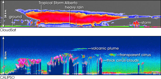
The images above show some of the first images collected by active remote sensors on the CloudSat (top) and CALIPSO (lower) satellites that NASA launched in spring 2006. The top image is a vertical cross-section of Tropical Storm Alberto, the first named storm of the 2006 Atlantic Hurricane season, captured by a radar on CloudSat on June 12, 2006. The bottom image is a vertical cross-section of the atmosphere that CALIPSO’s lidar saw as it passed northeast from a location near the southwest coast of Australia, across Indonesia and the Pacific Ocean, and over part of Japan on June 7, 2006. The image shows different layers of thin clouds and aerosol particles.
CloudSat’s radar can see into the heart of clouds. The colors in the image represent radar reflectivity, which is the strength of the signal that returns to the radar. Higher reflectivity (pinks and reds) in Tropical Storm Alberto indicates more ice and/or water in the cloud. The strip of green along the bottom is the echo of the radar off the ground. Where this line disappears beneath the storm shows the area of heaviest rain. A streamer of thinner cirrus clouds appears in shades of blue ahead of the storm; tucked under those clouds is another thunderstorm.
CALIPSO’s lidar reveals the geographic location and altitude of both clouds and aerosols, such as dust, sea spray, or pollution. The colors in the CALIPSO image indicate lidar backscatter, which is how much of the light pulse that the lidar sends out gets scattered back to it by particles in the air. Higher backscatter (white, pink, red) indicates thicker layers of cloud or aerosols. Bright pink and white areas around 10-15 kilometers altitude indicate layers of cirrus clouds. Whatever is below these clouds—probably cumulus clouds—is so thick that the lidar pulse could not penetrate here, and those “no data” areas are colored navy blue. To the right, a more transparent layer of cirrus appears as a red and yellow patch; a layer of aerosol (red) was observed beneath this cloud, near the ground. Also visible in the image is a thin, bright blue layer at about 20 kilometers altitude; this is likely a lingering plume of volcanic emissions from the eruption of the Soufriere Hills Volcano in the Caribbean Sea on May 20, 2006. Near the ground, the areas of high backscatter (red, orange, pink) are aerosol layers.
Atmospheric scientists use both radars and lidars to study the atmosphere because different frequencies of energy reveal different atmospheric characteristics. Lidars use higher-frequency (shorter wavelength) pulses of energy than radars. In general, the higher a sensor’s frequency, the smaller the particles it can detect. But the high-frequency signal is also more quickly “extinguished” by scattering and absorption by atmospheric particles. So, scientists can use radars and lidars to complement each other. Lidars detect small aerosols or thin clouds that might be invisible to lower-frequency radars, while radars can penetrate deeper into thick clouds that would extinguish a lidar signal.
Images courtesy NASA/JPL/NOAA/The Cooperative Institute for Research in the Atmosphere (CIRA), Colorado State University (top), and Kathy Powell, SAIC and NASA Langley Research Center (lower).