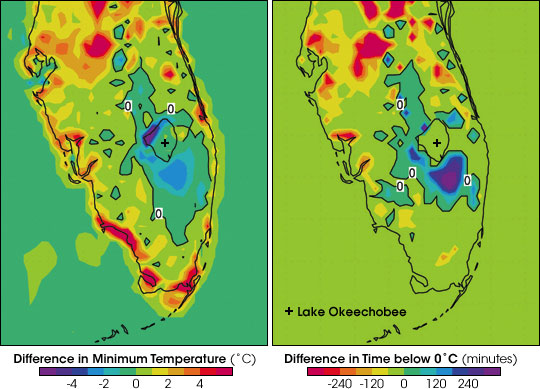


Prior to 1900, various wetlands ecosystems dominated the landscape of central and southern Florida. Throughout the 1900s, farmers and developers converted the wilderness into agricultural, urban, and suburban lands. Among the most significant transformations was the draining of the wetlands in the Kissimmee River floodplain in central Florida north of Lake Okeechobee. Because large bodies of water—including inundated wetlands—do not change temperature as quickly as dry land, the wetlands would have cooled the area during the heat of summer and warmed it on winter nights.
This pair of images shows how landscape change in central and southern Florida could have changed the daily minimum (coldest) temperatures (left) and the length of time a region spends below freezing (right). Purple and blue areas have an increased risk of damaging freezes, while yellow and red areas are less likely to freeze.
According to the simulation, the most damaging aspect of landscape-related climate change in Florida may be the decrease in minimum winter temperatures in the Kissimmee River floodplain and around Lake Okeechobee. Without the standing water to act like a hot water bottle, these areas of orange groves and sugarcane fields may experience colder temperatures and longer freezes today than they did in the past.
To learn more about how scientists from NASA, NOAA, Colorado State University, and the U.S. Geological Survey reconstructed the pre-1900 landscape of Florida and then predicted how the transformation may have changed today's climate, please read the feature story Deep Freeze and Sea Breeze.(Maps courtesy Curtis Marshall, Colorado State University/NOAA)