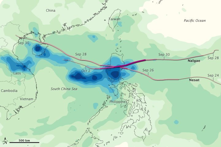


In a matter of five days, the Philippines and southeastern Asia were hammered by two intense tropical storms in late September and early October 2011. Several months worth of rain fell within a week—a deluge even by tropical standards—on Luzon in the northern Philippines, as well as in northern Vietnam and the Chinese island of Hainan.
This image shows average rainfall totals in the Western Pacific from September 26 to October 2, 2011, when Typhoon Nesat and Super Typhoon Nalgae passed through. The heaviest average rainfall—more than 350 millimeters or 14 inches—appears in dark blue. Localized rainfall amounts could be significantly higher. The lightest rainfall—less than 50 millimeters or 2 inches—appears in light green.
Superimposed on the rainfall totals are the storm tracks for Nesat and Nalgae, with maroon indicating the strongest storm intensity, and pink indicating the weakest. Typhoon Nesat reached category 3 strength, with winds estimated at 105 knots (120 miles/195 kilometers per hour) late on September 26, 2011, when it crossed into the heavily populated island of Luzon, Philippines. The storm weakened, but still maintained typhoon winds when it reached Hainan on September 29.
Nalgae was a category 4 super typhoon when it made landfall in the Philippines on October 1, with winds approaching 130 knots (150 miles/240 kilometers per hour). The storm was downgraded to tropical storm force, but was still approaching Hainan and Vietnam on October 3.
According to news reports, almost three million Filipinos were affected by the storms. At least 58 people were killed and another 28 were missing as of October 3. More than 300,000 people were being housed in evacuation centers, and damage estimates were approaching 8.8 billion pesos ($200 million U.S.). In southern China, roughly 140,000 people were evacuated, losses approached 1.6 billion yuan ($ 251 million U.S.), and at least four people were killed.
This image is based on data from the Multisatellite Precipitation Analysis (MPA) produced at NASA's Goddard Space Flight Center. The MPA estimates rainfall by combining measurements from many satellites and calibrating them against rainfall measurements from the Tropical Rainfall Measuring Mission (TRMM) satellite.