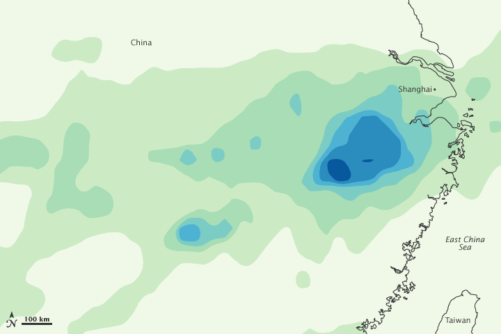


Continuing a pattern of heavy regional precipitation, torrential rains in late June 2011 forced more than 500,000 residents to evacuate in China’s central and eastern provinces. China Daily reported that millions of people were adversely affected in the provinces of Zhejiang, Jiangsu, Anhui, Jiangxi, Hubei, Hunan, and Guangdong. Flood waters submerged homes, crops, and roads, causing an estimated $772 million in damage in Zhejiang alone.
This image shows estimated rainfall amounts from June 13 to 19, 2011. The lowest rainfall amounts (less than 75 millimeters, or 3 inches) appear in pale green, and the heaviest amounts (more than 450 millimeters, or 18 inches) appear in dark blue. The heaviest rainfall occurs southwest of Shanghai.
A China Daily report from June 18 described the rains in parts of Zhejiang Province as unprecedented. High waters broke 100-meter (300-foot) holes in levees, inundating nearby villages. Some homes were buried in 3 meters (10 feet) of water. Farmers who managed to survive the floods wondered how they would survive the losses of their homes and crops.
On June 21, Agence France-Presse reported that another storm was nearing China’s southern coast, and was likely to bring strong winds and heavy rains to the provinces of Guangdong and Fujian over the next two days. Meanwhile, China Daily reported, risk of overflow prompted authorities at Xin’anjiang Reservoir in Zhejiang to open three of its nine floodgates.
The Washington Post has provided a photo gallery of the floods.
This image is based on data from the Multisatellite Precipitation Analysis produced at Goddard Space Flight Center, which estimates rainfall by combining measurements from many satellites and calibrating them using rainfall measurements from the Tropical Rainfall Measuring Mission (TRMM) satellite.
NASA Earth Observatory image by Jesse Allen, using near-real-time data provided courtesy of TRMM Science Data and Information System at Goddard Space Flight Center. Caption by Michon Scott.