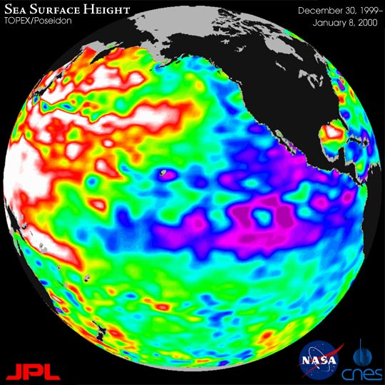


A giant horseshoe pattern of higher than normal sea-surface heights developing over the last year is beginning to dominate the entire western Pacific and Asiatic oceans, new imagery from the U.S.-French TOPEX/Poseidon satellite shows.
“Warmer and cooler than normal sea-surface temperatures influence our atmosphere every day, while sea-surface heights are a measure of how much heat is stored in the ocean below,” said Dr. William Patzert, an oceanographer at JPL. “When you put these two pieces of the climate puzzle together, they will tell us both about what is influencing today's weather and how much heat is being stored in the ocean to fuel future planetary climate events.”
The latest data, taken December 30, 1999 through January 8, 2000, show that this slow-developing condition covers most of the Pacific Ocean. The strength of this climate trend is seen in this TOPEX/Poseidon satellite image. Sea-surface height is shown relative to normal (green) height and reveals cooler water (blue and purple) measuring between 8 and 24 centimeters (3 and 9 inches) lower than normal along the coast of Central and South America, and stretching out into the equatorial Pacific. The giant horseshoe of warmer water (red and white) dominating the western and mid-latitude Pacific has higher than normal sea- surface heights of between 8 and 24 centimeters (3 and 9 inches). For the past year, warmer waters have been expanding slowly and are now beginning to dominate the western and north Pacific.
For more information, visit the JPL El Niño/La Niña watch.
Image courtesy TOPEX/Poseidon project, NASA JPL