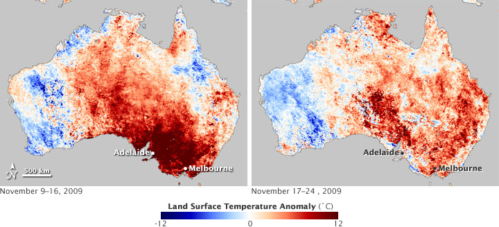


A spring heat wave scorched southeastern Australia in mid-November 2009, pushing the fire danger to the “catastrophic” category in parts of South Australia and New South Wales and to “extreme” in other surrounding areas. Many cities, including Melbourne and Adelaide experienced record-breaking temperatures that continued for many days.
This pair of images illustrates the impact of the heatwave on the land surface temperatures—which are different from the air temperatures reported in the daily weather report—across the continent. Based on observations from the Moderate Resolution Imaging Spectroradiometer (MODIS) on NASA’s Terra satellite, the maps show where temperatures from November 9–16 (left) and November 17–24 (right) were warmer or cooler than the average for those same eight-day periods between 2000–2008.
Around Adelaide in South Australia and Melbourne in Victoria, the land surface temperatures were up to 12 degrees Celsius (22 degrees Fahrenheit) above average in mid-November. For Adelaide, the event was the first springtime heatwave since records began in 1887, according to the Australian Bureau of Meteorology. The city had temperatures above 35 degrees Celsius (95 Fahrenheit) for 8 consecutive days. (Five days at those temperatures constitutes a heatwave). Later in the month, some areas experienced heavy rain, which broke the heatwave in some areas, but not all.
According to the weather and climate agency, the heat wave resulted from a combination of factors: gradually rising temperatures across southern Australia, probably as a result of global warming; an El Niño event in the Pacific Ocean; and a high-pressure weather system that stalled out over the Tasman Sea to the southeast, causing hot, dry winds to blow south over continent.
NASA Earth Observatory image by Kevin Ward, based on land surface temperature anomaly data from the NASA Earth Observations (NEO) Website. Caption by Rebecca Lindsey.