

high resolution images:
true color (1.2 MB JPEG)
optical thickness (1.9 MB JPEG)
effective radius (1.9 MB JPEG)
Clouds are one of the most dominant features in any space-based image or photo of the Earth. At any given time, our world is almost completely swathed in clouds; they cover roughly 60 percent of our planet’s surface area. Here on terra firma, most of us are too grounded to pay much attention to these silent shapes passing slowly by, like sails billowing far away in the sky. For most of us, clouds are the stuff of idle daydreams.
Yet clouds are not irrelevant to us, and they are far from idle. Indeed, they are key components in the Earth’s climate system. Even as they pour life-giving water across Earth’s landscapes, they also protect us from the sun’s burning rays. They act as brokers between the surface and the atmosphere, trading moisture for heat and vice versa. The very process of their formation releases a tremendous amount of heat energy into the atmosphere—spreading warmth carried by air currents to other parts of the globe. And they act as brokers between the surface and outer space, regulating the flow of radiant energy to and from our world.
It is no surprise then that clouds have attracted the attention of Earth scientists. And yet, even as we examine clouds in more detail than has ever before been possible, we’re discovering how much more there is to learn about them. One area of scientific debate seeks to define precisely what is a cloud—i.e., where does a cloud’s edges begin and end? Other scientists hope to determine how clouds will respond if there is continued global warming due to the build up of greenhouse gases. Will they change to counteract the global warming trend, or could they possibly change to enhance it? Based upon these and other considerations, the Intergovernmental Panel on Climate Change (IPCC) reports that clouds represent the area of greatest scientific uncertainty in understanding how Earth’s climate system works.
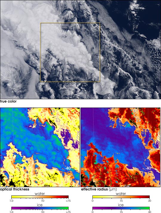
Among the tools now available to scientists for studying clouds, NASA’s Moderate Resolution Imaging Spectroradiometer (MODIS) measures a suite of cloud properties every day over almost the entire planet. The images above show two cloud properties measured by MODIS, flying aboard NASA’s Terra satellite, over the Indian Ocean due south of Australia. The top panel shows the scene in true color, while the bottom panels are false-color images representing measures of how little sunlight is allowed to travel down through the column of atmosphere (optical thickness, bottom left), and the size of the particles making up the clouds (effective radius, bottom right). MODIS can also distinguish those clouds made up of water droplets (yellows and reds) from those comprised of ice crystals (purples and blues).
The scene is scientifically interesting because it shows a variety of cloud types in an unstable atmosphere. There is an optically thick ice cloud in the center of the image overlying optically thin water clouds. The small, thick cells in the ice cloud (green patches in the bottom left panel) are also evident in the true-color image.
On a global scale, how much radiant energy do clouds reflect and emit to outer space? How much heat do they trap and re-radiate back toward the surface? How much water do clouds hold? These new measurements from MODIS are helping scientists answer these and other important questions. For further cloud appreciation, please see:
Feature articles:
Reference articles:
Images courtesy Mark Gray, MODIS Atmosphere Science Team, NASA GSFC