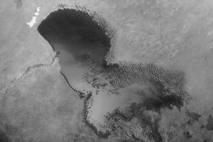
An astronaut aboard the International Space Station took this photo while orbiting over Africa’s Sahel region—a savanna zone that lies between the Sahara Desert and the rain forests of Central Africa.
The circular Lake Iro, known locally by its French name “Lac Iro,” stands out against the vegetated landscape of southeastern Chad. Smoke plumes from several fires are visible at the top and bottom of the scene, with a small fire in the center. The plumes indicate that the wind on this day was blowing toward the west.
The lake measures approximately 12 kilometers (7 miles) in diameter. Both the river that supplies the lake with water and the lake itself appear bright in this view. This effect results from water surfaces reflecting sunlight directly back to the camera, a phenomenon known as sunglint. Astronaut photographers use sunglint as a photographic technique to reveal details in Earth’s water that can be difficult to see under other lighting conditions.
The area shown in the image lies in the middle of one of Africa’s largest “inland deltas,” which was formed by river water from the Bahr Salamat. Two arms of the Salamat are visible in this image. One displays brilliant sunglint (center), and the other displays partial sunglint (top left). The general direction of water flow in both arms is toward the southwest.
The image shows two different meander patterns along the Bahr Salamat. Small meanders with wavelengths of 1-2 kilometers are visible along the river’s south arm toward the center of the image. In contrast, ancient meanders on the left side of the image are substantially larger, with single meanders measuring more than 10 kilometers. Larger meanders indicate that the Salamat had a greater discharge of water and sediment in the past.
Human activity appears in the form of lighter-toned areas of deforestation around towns such as Boum Kabir, located on the northern shore of Lake Iro. A road is faintly visible on the lower margin near a series of wetlands.
Astronaut photograph ISS072-E-400084 was acquired on December 21, 2024, with a Nikon Z9 digital camera using a focal length of 200 millimeters. It is provided by the ISS Crew Earth Observations Facility and the Earth Science and Remote Sensing Unit, Johnson Space Center. The image was taken by a member of the Expedition 72 crew. The image has been cropped and enhanced to improve contrast, and lens artifacts have been removed. The International Space Station Program supports the laboratory as part of the ISS National Lab to help astronauts take pictures of Earth that will be of the greatest value to scientists and the public, and to make those images freely available on the Internet. Additional images taken by astronauts and cosmonauts can be viewed at the NASA/JSC Gateway to Astronaut Photography of Earth. Caption by Justin Wilkinson, Texas State University, Amentum-JETS II Contract at NASA-JSC.