
Before he became known as “John of the Mountains” in the high country of California, naturalist John Muir journeyed through a different type of challenging terrain: the swampy lowlands of the U.S. Southeast. But true to form, he reveled in the diverse flora along the way. Traveling south, he anticipated his arrival in Florida, “the special home of the tropical plants I am looking for,” where among those tropical plants he would find “clumps of mangrove.”
Like Muir, scientists today undertake the arduous task of exploring mangrove stands from the waterlogged ground. But unlike the naturalist of centuries past, researchers in the satellite era benefit from having a bigger picture view of mangrove habitat, as well. Observing the habitats from both vantage points, scientists have recently uncovered previously unmapped mangrove territory along the U.S. East Coast. The results point to a rapid expansion in the range of these valuable coastal trees.
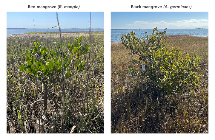
On the ground, a team surveying tidal marshes near the Florida–Georgia border in 2024 found red mangroves (Rhizophora mangle) and black mangroves (Avicennia germinans) growing 50 miles (80 kilometers) and 14 miles (23 kilometers) farther north, respectively, than their previously documented range. The scientists believe these discoveries, described in a March 2025 report, constitute the first record of naturally occurring mangroves in Georgia.
The locations of these pioneering mangroves are shown on the image above, acquired with the OLI-2 (Operational Land Imager-2) on Landsat 9 on March 11, 2025. The trees were found growing in salt marshes at the mouth of the Saint Marys River. Although the young plants are too small to be visible at the resolution of this image, Landsat and other satellite imagery are valuable for monitoring marsh-to-mangrove transitions over larger areas and longer time frames.
Conditions along the U.S. East Coast are conducive to mangrove territory expansion. The study authors point to less-frequent extreme cold events and rising winter temperatures in the region as contributing factors to the trees’ survival.
The geography along the southeastern U.S. coast and mangroves’ method of reproduction combine to work in favor of their expansion, as well, said Cheryl Doughty, an assistant research scientist at NASA’s Goddard Space Flight Center and the University of Maryland. The trees send out small, specialized seedlings called propagules that can be transported by tides and currents. “If they are lucky enough to settle in the right conditions, they may establish,” she said.
The Gulf Stream flows north along the southeastern U.S. coast, with no real geographic barrier to impede the propagules. Tides can carry them into inlets such as the one shown above, where they might anchor in salt marshes. “These inlets are like safe havens from oceanic forces,” Doughty said.

Additional forces such as rising sea levels and storm events might push mangrove seedlings to higher elevations in the salt marsh, giving them a better chance of success. One can think of the dynamics as a “press and pulse” of regional climate drivers, she explained, where warming and sea level rise are continuous “presses” over the long term, and an event such as a hurricane is a “pulse” disturbance.
Though Doughty was not affiliated with the March 2025 report, she has seen the expansion of mangroves in the Southeast in her own work using a suite of NASA, ESA, and commercial satellite products. In a 2024 study, she and her collaborators detected over 240 hectares (590 acres) of previously unmapped mangroves along the northeast Florida coast. It is important to track these habitat shifts, the authors argue, because of the associated changes to ecosystem services such as carbon storage and coastal protection.
Field surveys, although time- and labor-intensive, remain crucial for finding young trees in new areas. Linking these observations with satellite imagery will continue to be important for scientists tracking the long-term northward shift of the mangrove range on the U.S. East Coast. “Consistent, trustworthy, and accessible satellite data make monitoring the rapid changes of Earth’s surface possible,” said Doughty.
NASA Earth Observatory image by Michala Garrison, using Landsat data from the U.S. Geological Survey and mangrove location data from Vervaeke, W.C., et al. (2025). Photos of mangroves in Georgia courtesy of William C. Vervaeke/NPS. Story by Lindsey Doermann.