A powerful mid-latitude cyclone delivered a potpourri of weather hazards as it worked its way across the United States in March 2025. Beginning on March 3, the low-pressure system fanned wildfires and blinding dust storms in the Southwest, spawned severe thunderstorms and tornadoes in the Southeast, fueled blizzards in the Great Plains and Midwest, and dropped heavy rain in the Northeast.
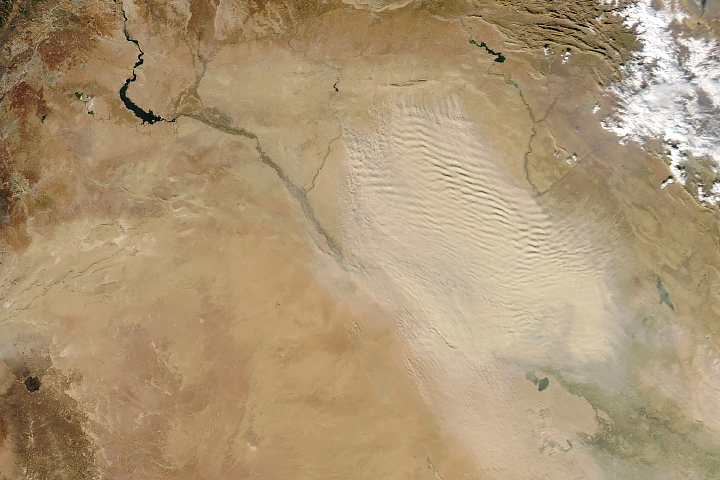
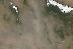
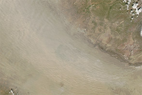
Thick plumes of dust streamed across West Texas in this image, captured on March 4, 2025, by the MODIS (Moderate Resolution Imaging Spectroradiometer) on NASA’s Terra satellite. Clouds of dust appear to originate from arid landscapes in northern Mexico and West Texas, a region that spans the Chihuahuan Desert, cattle ranches and cotton farms, and gas and oil fields.
Exceptional drought has gripped West Texas for the past several months, according to the U.S. Drought Monitor. The lack of rain has parched vegetation and dried the land surface, making the region particularly susceptible to erosion and dust storms.
Fierce winds and thick plumes of blowing dust led to traffic accidents, flight disruptions, school closures, power outages, and red and orange skies throughout the state and region, according to news reports. One particularly severe dust storm on March 3 sharply reduced visibility and contributed to a 21-car accident near Roswell, New Mexico.
“This is a large event, but dust storms are typical in this region at this time of year,” said Santiago Gassó, a University of Maryland atmospheric scientist based at NASA’s Goddard Space Flight Center. “Unfortunately, we’re seeing longer droughts in the southwestern U.S. and northern Mexico, so we can expect more of this type of event.”
Tools powered by NASA data and satellites are available to meteorologists, scientists, and others tracking the storm. The Worldview browser hosts timely data and imagery from several satellites. A data viewer from NASA’s Short-term Prediction Research and Transition Center (SPoRT) provides access to rainfall, lightning, air quality, and other data, and NASA’s Global Modeling and Assimilation Office has tools for real-time weather analysis and reanalysis.
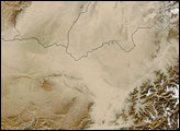
One of the newer data products comes from an experimental aerosol detection algorithm that NOAA’s AerosolWatch team is developing. The algorithm makes it easier to distinguish between dust and smoke, both of which were present in the hazy plume over Texas on March 4, by merging data collected by the TEMPO (Tropospheric Emissions: Monitoring of Pollution) mission with ABI (Advanced Baseline Imager) observations from the GOES-19 satellite.
New Aerosol Detection Product (ADP) from merged TEMPO & GOES-19 ABI observations highlights blowing dust along a cold front across TX & NM on 3 Mar; yellow indicates thin dust & dark brown indicates thick dust. @CenterForAstro @TEMPO_Mission @NOAASatellites @Karma_lobsang12 pic.twitter.com/p6WGKrkOET
— AerosolWatch (@AerosolWatch) March 4, 2025
“The combination of TEMPO with GOES is very promising,” Gassó said. “Both satellites make multiple observations each day, and given their combined observations at several spectral channels, we’re able to fully characterize smoke or dust in time, space, and concentration for the first time.”
NASA Earth Observatory image by Michala Garrison, using MODIS data from NASA EOSDIS LANCE and GIBS/Worldview. Story by Adam Voiland.