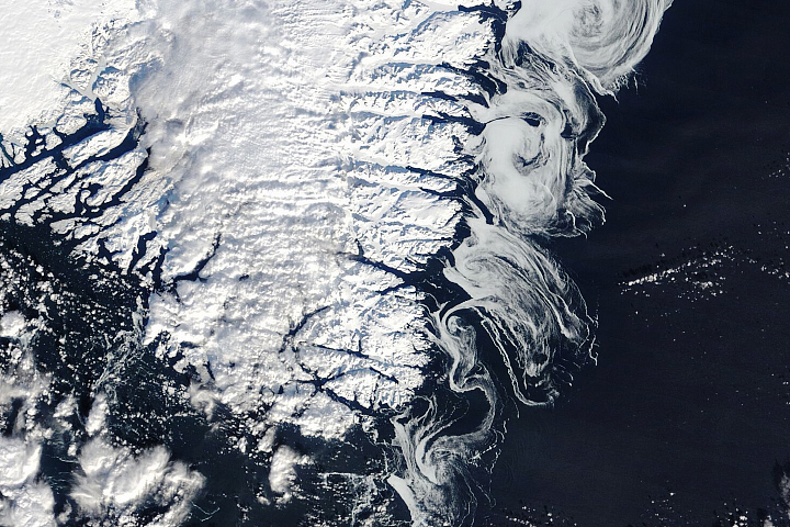
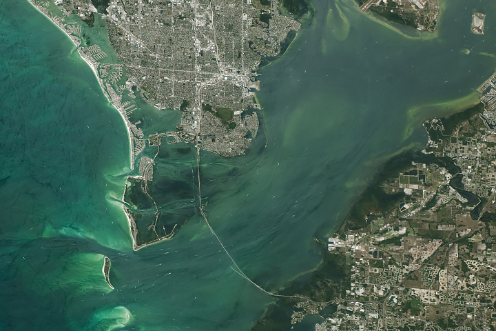
Over tens of thousands of years, the cyclical advance and retreat of glaciers carved the distinctive U-shaped valley that now holds the waters of Kachemak Bay, one of the most productive and biodiverse estuaries in the state of Alaska.
Glaciers east of the bay grind over bedrock and enrich runoff with bits of pulverized rock called glacial flour. Several meltwater streams rich with the particles, sometimes called suspended sediment, absorb and scatter sunlight in ways that turn water a milky blue-green hue. The water that flows into the bay from the Grewingk-Yalik Glacier Complex to the east carries sediment-infused waters that transform the appearance of the bay during the summer, raising questions about how much the influx of sediment affects the bay’s marine life.
The OLI (Operational Land Imager) on Landsat 8 captured an image (above) of the bay’s turbid, cloudy waters on September 20, 2024. In a wider view (below), ocean water west of the bay in the Cook Inlet has a more typical dark blue color.
An especially thick plume of sediment is visible as it pours into the bay from Grewingk Glacier, a 21-kilometer (13-mile) glacier in the Kenai Mountains. Like many other glaciers in the region, Grewingk has retreated significantly in recent decades. According to one analysis from Nichols College glaciologist Mauri Pelto, the terminus of the shrinking glacier has shifted by more than 2.5 kilometers (1.5 miles) since 1950, a process that has doubled the size of the lake at the front of the glacier and likely increased the volume of sediment entering the bay.

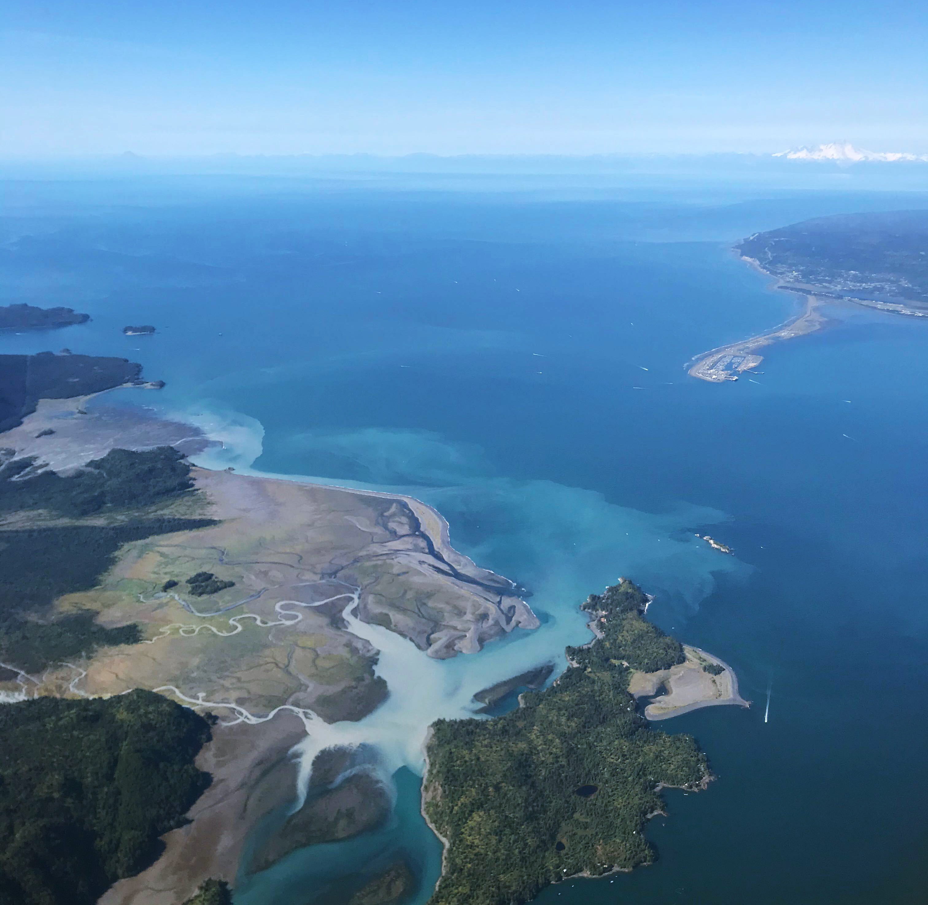
Lea Hartl, a glaciologist with the University of Alaska Fairbanks, is part of a team that has focused on mapping Kachemak Bay’s sediment plumes. The researchers collected hyperspectral observations of the bay’s water color and sediment during a series of nine flights conducted between 2019 and 2021. The photograph below, taken by University of Alaska atmospheric scientist and state climatologist Martin Stuefer during one of the flights, shows cloudy water from the Wosnesenski River and Stonehocker Creek entering the bay with the Homer Spit in the distance. The researchers analyzed dozens of Landsat images collected between 1983 and 2023 to help characterize the size, seasonality, and longevity of the plumes.
In a study published in the Journal of Hydrology: Regional Studies, Hartl and colleagues reported that sediment plumes were smallest in May and October, when there was little water running off the glaciers, and largest and most concentrated in July and August when glacier melt produced high volumes of seasonal runoff. During summer, the cloudy plumes affected about a quarter of the bay on average. The researchers also showed that plumes from Grewingk Creek, a stream flowing from Portlock Glacier, and streams at the head of the bay often merged and spread across the entire inner bay during peak melt season.
The shallow waters of the subarctic estuary host an unusual abundance of marine life. Hartl and other researchers are scrutinizing Kachemak Bay in part to better understand how the bay’s milky waters affect this life, which supports recreational fisheries, aquaculture, and tourism. Previous research suggests turbid waters may benefit certain types of phytoplankton, seaweed, shellfish, and fish while harming others.
Tiny species of phytoplankton, including diatoms and dinoflagellates, live in the bay along with seagrasses, kelps, and other aquatic plants that thrive in the chilly, nutrient-rich waters. A 28-foot tidal range creates a wide intertidal zone with clams, mussels, crabs, snails, and other invertebrates. Dozens of species of shorebirds and waterfowl also frequent the bay. Otters, seals, porpoises, and whales live in its waters along with salmon, halibut, herring, and an array of other fish.
“Sediment plumes have been mapped using various kinds of remote sensing imagery in different regions of the world, but not previously in Kachemak Bay,” Hartl said. “Hyperspectral imagery of ocean water is generally rare, especially in high-latitude waters.”
While Hartl did not directly study how the sediment affects the bay’s marine life, other researchers who were part of a broader University of Alaska research effort called Fire and Ice did. One team published results showing that marine communities including mussels, barnacles, and rockweed had lower species richness near sources of freshwater and sediment than communities living elsewhere in the bay. Another study found that Starry flounder were larger in areas with cloudier waters.
“Our remote sensing work was a nice addition to the work others did at specific locations because it gives a sense of scale and helps connect individual sampling points to the bay as a whole,” added Hartl.
NASA Earth Observatory images by Michala Garrison, using Landsat data from the U.S. Geological Survey. Aerial photograph by Martin Stuefer (University of Alaska). Story by Adam Voiland.