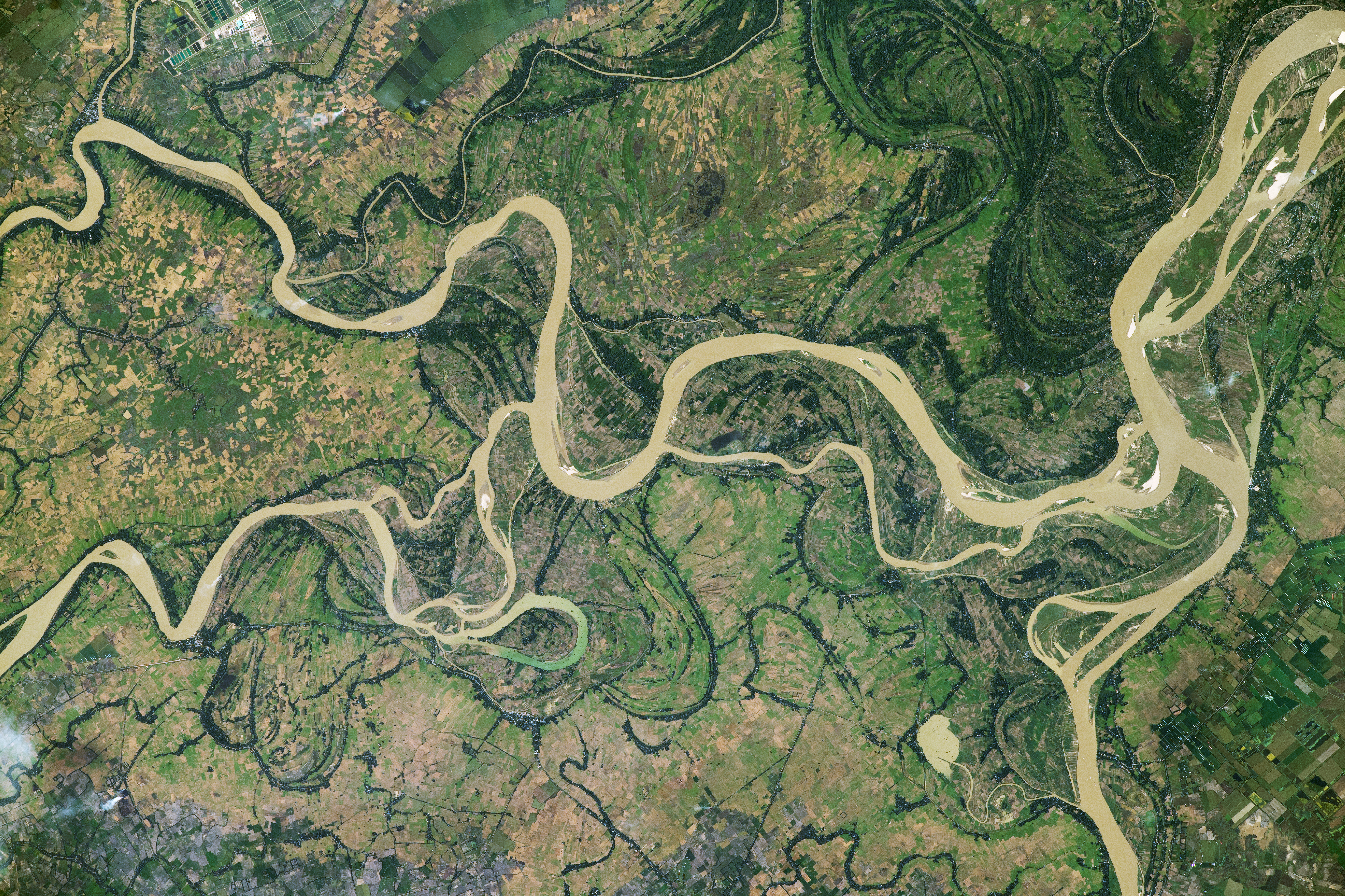
An astronaut aboard the International Space Station took this photograph of the Irrawaddy River while orbiting over Southeast Asia. The Irrawaddy is the largest waterway in Burma (Myanmar), originating in the northern part of the country and flowing approximately 2,170 kilometers (1,350 miles) south before emptying into the Andaman Sea. Sediment in the water gives the river an opaque, light brown appearance, except for a light green portion of water near Yelegale.
This portion of the Irrawaddy River lies in the Ayeyarwady region approximately 65 kilometers (40 miles) west-southwest of Yangon, the country’s former capital city. The region is part of the northern Irrawaddy River delta, where the river begins to split from its central trunk. Several splits in the river’s path are visible, with two large distributaries forming near Chaunggyi and Aunghlaing.
Older channels visible across the photo indicate changes in the Irrawaddy River’s course. The most obvious examples wind across the top-right of the image. Dark green vegetation lines the banks of these prior river channels.
Evidence of agricultural production appears throughout this part of the river’s floodplain. The region—nicknamed the country’s “rice bowl”—is shown here in December, which correlates with the crop’s typical harvest season. In addition to field crops, the region is also a center for raising livestock, such as chickens, cows, and pigs.
Fish farming is also an important activity. The pools of a fish farm (top-left) appear bright as they reflect sunlight back toward the astronaut’s camera. Aquaculture allows farmers to utilize land in low-lying regions that are otherwise too flood-prone to cultivate crops during the monsoon season.
Astronaut photograph ISS070-E-42458 was acquired on December 16, 2023, with a Nikon D5 digital camera using a focal length of 400 millimeters. It is provided by the ISS Crew Earth Observations Facility and the Earth Science and Remote Sensing Unit, Johnson Space Center. The image was taken by a member of the Expedition 70 crew. The image has been cropped and enhanced to improve contrast, and lens artifacts have been removed. The International Space Station Program supports the laboratory as part of the ISS National Lab to help astronauts take pictures of Earth that will be of the greatest value to scientists and the public, and to make those images freely available on the Internet. Additional images taken by astronauts and cosmonauts can be viewed at the NASA/JSC Gateway to Astronaut Photography of Earth. Caption by Cadan Cummings, Amentum, JETS II Contract at NASA-JSC.