Kevin Kregel had his lucky fishing hat firmly in place, complete with an array of fishing tackle above the floppy brim and a chinstrap cinched up tight. It was time to try the fly-cast maneuver. Commander Kregel wasn’t out for trout on a mountain stream. He was at the controls of the space shuttle Endeavour. Instead of wielding a fly-fishing rod, he and the crew of the 97th shuttle mission were preparing to whip a slender, 200-foot-long mast into place on day two of their 11-day quest to create an unprecedented map of Earth.
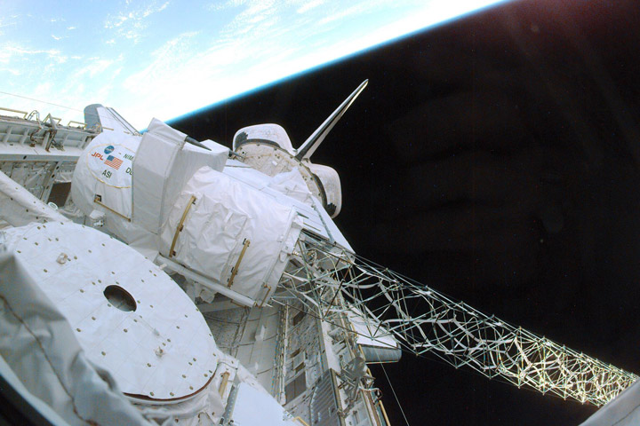
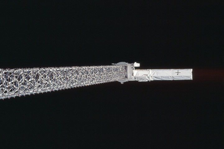
With one end mounted in the orbiter’s payload bay and the other cantilevered out into space, the mast was a central part of the Shuttle Radar Topography Mission (SRTM). It was also the longest instrument ever flown aboard a space shuttle. A detector at the end of the mast and one nestled inside the shuttle bay were ready to collect reflections from a radar beam aimed at Earth below. First, there was the matter of swinging the fragile mast around to precisely orient the instrument in orbit. Doing it with a detector as heavy as a grand piano attached to the far end was going to be the tricky part.
Nearly a quarter century after the mission to map the world, the SRTM’s data still yields results. Just this year, it aided in wildfire forecasting for Iran’s Zagros Mountains, tracking soil erosion in South Africa, assessing flood risk on the coast of Brazil, and even determining how the locations of power-generating wind turbines affect real estate values. Tens of thousands of research papers are published every year that rely on SRTM maps for these and other environmental, economic, agricultural, and public safety studies.
Back when Endeavour launched on February 11, 2000, much of Earth’s surface was a mystery, topographically speaking. No one knew the precise heights of many of the world’s mountains or the depths of the valleys between them. Where height information did exist, topographical maps varied in quality and scale from country to country. The result was an incomplete patchwork of maps.
Prior to 2000, correcting these mapping deficiencies had proven elusive. Most imaging satellites had a hard time seeing through cloud cover, particularly over portions of South America and Africa; it was expensive to fly mapping instruments on planes crisscrossing remote regions; and in some cases, countries denied access to airborne mapping efforts due to political conflicts. Scientists and engineers at NASA’s Jet Propulsion Laboratory set out to solve the problems with an instrument that could see through clouds and map much of the planet over the course of a single space shuttle mission.
Their solution was the SRTM instrument that now hangs from the ceiling in the Smithsonian National Air and Space Museum’s Steven F. Udvar-Hazy Center in Fairfax County, Virginia. Only a fraction of its fragile mast extends from the golden canister where it was stored for the trip to orbit and back. Fully deployed, the trusswork of slender rods would reach two-thirds the length of a football field. When packed away, the entire thing collapsed like an accordion to fit in the canister, which is a bit taller than the average adult.
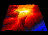
The radar system at the heart of the SRTM instrument had flown twice on Endeavour for prior mapping efforts. During those missions, the instrument offered two-dimensional views of the ground from orbit. By combining data from different vantage points, NASA scientists produced stereoscopic images that revealed stunning 3D topographic views. But the need for multiple passes over the locations slowed the process, and while clouds are transparent to radar, changes in the atmosphere between orbits limited the quality and accuracy of the resulting maps. The missions primarily focused on areas of scientific interest in South America, Africa, Europe, Asia, and Oceania, covering about 10 percent of the planet’s surface on each of the two flights.

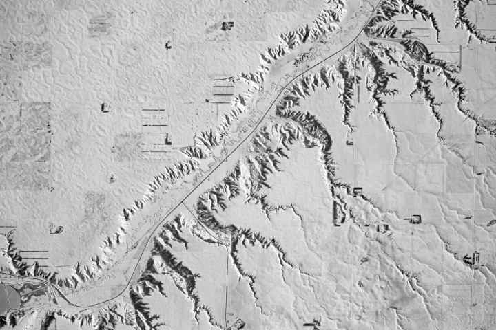
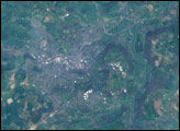
With a radar antenna mounted at the end of the SRTM mast and another inside the shuttle bay, the new instrument could continuously view Earth in 3D, ensuring that atmospheric changes from one orbit to another were no longer a problem. Because it could capture images in a single pass over any given area, the SRTM would be able to scan large areas of the planet and reveal detailed topography nearly ten times faster than its predecessor. In total, the SRTM collected elevation data over 80 percent of Earth’s landmass in a single flight, with coverage spanning the areas visible in the maps at the top of this page.
If not for the weightlessness of orbit, a thousand-pound radar antenna would have been far too heavy for the delicate mast to handle. But even in space, there’s still the problem of inertia—the resistance of things with mass to changes in motion. That meant that the SRTM mast was going to flex whenever the spacecraft turned to put the instrument in position to map the planet below. Despite its rigid design, the long mast would act like a spring, with the antenna wobbling at the end after any shuttle maneuvers.
“It’s a very small angle wobble, less than a degree,” said Scott Hensley, a senior research scientist at JPL who helped develop the SRTM instrument, “but it translates into big error.” The motion would have amounted to inaccuracies on the order of a thousand feet (300 meters) in features on a topographical map.
The JPL design team had anticipated the flexing and installed a system of gas jets at the end of the mast to counteract the wobble. “It was a really clever idea,” Hensley said. “It worked for like a day and a half, and then I think it froze, so it no longer ejected the gas.” Fortunately, engineer Bill Layman had outlined a fly-casting contingency plan in the event of a problem with the jets. Which brings us to Kregel and his fishing hat.

Layman’s fly-cast maneuver mimicked the motions that sport fishers use when casting with long, flexible fly-fishing rods. In order to rotate the SRTM mast into position, Kregel (pictured above, left) and Endeavour pilot Dominic Gorie first applied a short burst with the shuttle’s thrusters, comparable to the initial flick of a fly rod. That caused the mast to bend backward slightly as the shuttle turned, and then to rebound forward. When the mast straightened out, a second burst of the thrusters sped up the shuttle’s rotation, mimicking the forward portion of a cast. The timing and strength of the thrusts were tuned to prevent further vibrations as the mast swung into place. Reversing the thruster procedure brought everything to a quiet, vibration-free halt, with the radar system in position to start mapping.
Unlike the frozen gas jets, the fly-cast maneuver relied on the shuttle’s limited supply of thruster propellant. That meant the technique had the potential to cut the mission short. But Kregel and Gorie managed the fly-cast maneuver to reposition the SRTM on six occasions with enough efficiency to leave plenty of propellant to complete the full mapping schedule. The deft piloting allowed the shuttle team enough time to collect elevation data over most of Earth’s landmass, between the southern tip of Greenland and the southern tip of South America.
Read more about SRTM’s treasured maps in the story’s second installment.
NASA Earth Observatory image by Michala Garrison, using topographic data from the Shuttle Radar Topography Mission (SRTM) and SRTM coverage boundary data from the United States Geological Survey (USGS). Photos and illustration from the NASA image and video library, STS-99. Story by James Riordon/NASA’s Earth Science News Team.