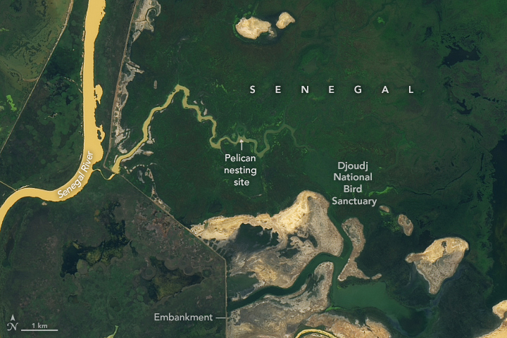


About 5,000 years ago, global sea level was higher and water covered the Senegal River Delta. As time passed and the ocean retreated, rivers remade the surface of the newly exposed landscape, moving sediment during floods and scouring channels to create an intricate network of lakes, lagoons, floodplains, and islands.
The delta wetlands became an oasis amidst the mostly barren desert landscapes of northern Senegal and southern Mauritania. The mixture of fresh and salt water, and dynamic seasonal floods, attracted many species of birds, and the wetlands became a nesting, wintering, and stopping point for a range of migratory and resident birds on the East Atlantic Flyway.
Construction of the Diama Dam about 22 kilometers (14 miles) north of Senegal’s historic city of Saint-Louis in 1986 changed the seasonal rhythms of the delta’s waterways. The dam stored fresh water for farmers in the region, but it stopped tidal flows of salt water during the drier months that helped sustain some wetland areas. The freshwater reservoir that pooled up behind the dam would have flooded Senegal’s Djoudj National Bird Sanctuary, established in 1971, without the construction of a network of embankments, sluice gates, and canals that regulate how much water flows through the bird sanctuary and reservoir.
Sections of this water management system are visible in satellite images. In the image above, captured by the OLI (Operational Land Imager) on Landsat 8, embankments appear as relatively straight lines surrounding green areas. The reservoir and surrounding wetlands appear mostly green because thick communities of aquatic vegetation thrive in the shallow water.
Diawling National Park was established in Mauritania in 1991 after the construction of the Diama Dam, partly to restore a more natural flow of water to areas west of the reservoir. Seasonal water releases have helped rehabilitate mangroves and other wetlands that had begun to wither after the construction of dam.
Every year, millions of migrating birds pass through the sanctuary and national park, temporarily joining populations of resident birds. Ducks, sandpipers, flamingos, pelicans, spoonbills, herons, cormorants, garganeys, pintails, and ruffs are all commonly found in this area. More than 10,000 pelicans typically nest on a flat, triangular area of rock found in the bird sanctuary. The nesting rock likely appears white in the Landsat image compared to the surroundings because of the high density of white birds and guano stains.
NASA Earth Observatory images by Lauren Dauphin, using Landsat data from the U.S. Geological Survey. Story and photograph by Adam Voiland.