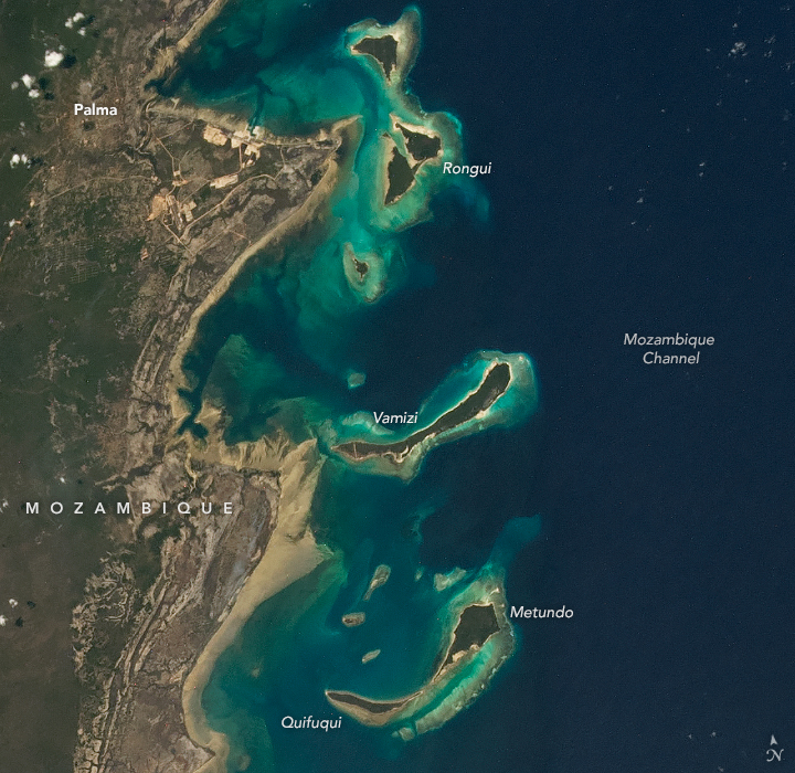

The Quirimbas Islands stretch 322 kilometers (200 miles) along Mozambique’s coastline and are teeming with an impressive array of plants and animals. The 32 small islands that make up the archipelago are partly linked to the coast by mangroves, sand bars, and coral reefs.
An astronaut on the International Space Station took this photograph of the northern part of the Quirimbas Islands, near the Tanzania border, on November 24, 2021. Light blue-green water highlights the shallow complex of corals, sand, and seagrass surrounding the islands.
In 2018, the United Nations Educational, Scientific and Cultural Organization (UNESCO) selected the islands to be protected as one of its 738 biosphere reserves because of its unique biodiversity. According to UNESCO, the islands are home to 3,000 floral species, of which 1,000 are endemic, meaning they are only found on the islands.
The islands’ waters host 52 species of corals, 140 species of mollusk, and eight species of marine mammals including whales and dolphins. Five species of sea turtles are found there: loggerhead turtle (Caretta caretta), green turtle (Chelonia midas), leatherback turtle (Dermochelys coriacea), hawksbill turtle (Eretmochelys imbricata) and olive ridley (Lepidochelys olivacea). All five of these species are listed by the International Union for Conservation of Nature as being threatened with extinction.

Vamizi, the long crescent-shaped island centered in the image above, is one of the largest islands of the Quirimbas Archipelago. The island is an important nesting site for hawksbill turtles and green turtles. Some 170 green turtle nests were observed on the island during 2019 and 2020, making it the species’ largest nesting site in Mozambique.
Increased tourism and fishing on and around Vamizi island in recent years has put pressure on the island’s marine ecosystem. Certain fishing methods are hazardous to sea turtles, which can get accidentally caught in nets and tangled in fishing gear.
Concern about the health of marine species near the island led to the creation of Community Fishers’ Council (the Conselho Comunitário de Pesca), which established the Vamizi Community Sanctuary on the western side of the island as a no-fish zone. The sanctuary covers about 10,000 hectares of reefs, mangroves, and deeper waters, and extends 5 kilometers out to sea.
Astronaut photograph ISS066-E-81982 was acquired on November 24, 2021, with a Nikon D5 digital camera using an 70 millimeter lens and is provided by the ISS Crew Earth Observations Facility and the Earth Science and Remote Sensing Unit, Johnson Space Center. The image was taken by a member of the Expedition 66 crew. The image has been cropped and enhanced to improve contrast, and lens artifacts have been removed. The International Space Station Program supports the laboratory as part of the ISS National Lab to help astronauts take pictures of Earth that will be of the greatest value to scientists and the public, and to make those images freely available on the Internet. Additional images taken by astronauts and cosmonauts can be viewed at the NASA/JSC Gateway to Astronaut Photography of Earth. Story by Emily Cassidy.