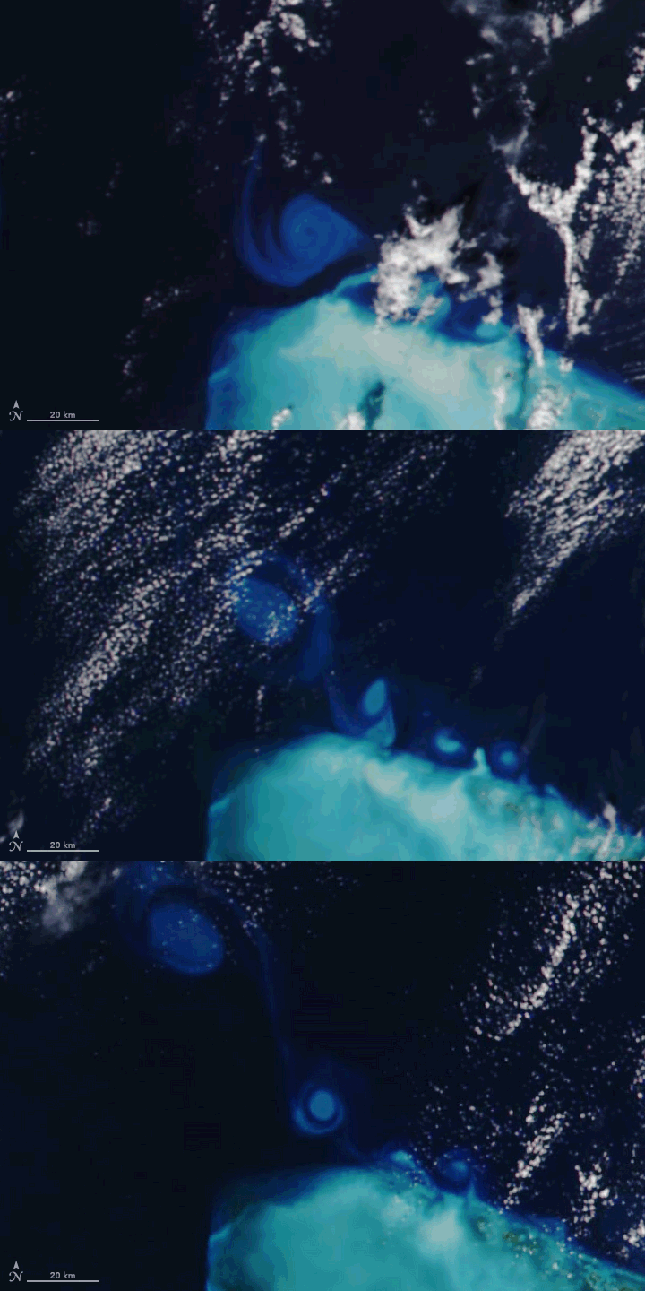


In November 2022, Tropical Storm Nicole barreled into the Bahamas and then hit central-east Florida as a hurricane. The storm brought flooding and hundreds of millions of dollars of damage to the region. But offshore, it stirred up something unusual and beautiful: a series of eddies along the Abaco Islands in the northern Bahamas.
The group of satellite images above show several small eddies swirling out from shallow waters along the Little Bahama Bank’s carbonate platform. Similar swirls in the world’s oceans are sometimes colored by large concentrations of certain types of phytoplankton—microscopic plant-like organisms that in abundance can discolor water and be seen from space. But Chuanmin Hu, an oceanographer at the University of South Florida, thinks the color of these swirls has another explanation.
“I don’t think the swirls are phytoplankton because phytoplankton do not generally have such bright colors,” Hu said. “These are more likely carbonate-rich silt particles that were resuspended by Nicole, then washed offshore, and then caught up in surface currents.”
The Visible Infrared Imaging Radiometer Suite (VIIRS) on the NOAA-20 and Suomi NPP satellites acquired the natural-color images between November 11-13, 2022. The image below, captured by the Multispectral Instrument on the European Space Agency’s Sentinel-2 satellite, shows a more detailed view of one of the swirls on November 11.
The series of swirls appear to be the product of a type of fluid flow called vortex shedding—an oscillating flow that creates a repeating pattern of swirling vortices. Vortex shedding occurs when a fluid moves around blunt objects at certain velocities.
The swirls of water likely contain mostly small particles. “The strong winds of Nicole would have caused significant resuspension of all sediment particles—both large sand particles (light brown) and much smaller carbonate-rich silt (light blue). The large particles would have sunk quickly to the bottom in a couple of days, but the small silt particles can remain suspended for more than a week,” said Hu.
Some of the sediment that was stirred up was likely spread throughout the area by earlier whiting events. These occur when large numbers of suspended calcium carbonate particles cloud patches of water.
Whiting events are known to happen frequently in this area, but why they occur is something of a mystery. Some scientists have theorized that whiting events could be triggered by changes in water temperature, the presence of certain types of phytoplankton blooms, or the resuspension of carbonate mud by winds or even by large schools of fish.
NASA Earth Observatory images by Joshua Stevens, using VIIRS data from NASA EOSDIS LANCE, GIBS/Worldview, and the Joint Polar Satellite System (JPSS) and modified Copernicus Sentinel data (2022) processed by the European Space Agency. Story by Adam Voiland.