
Just over three months into 2022, Sydney, Australia, has already received a year’s worth of rain. The recent deluge brought more flooding to the already rain-soaked southern and central coasts of New South Wales, prompting evacuations.
On April 7, torrential downpours brought a month’s worth of precipitation—more than 100 millimeters (4 inches) —to parts of the city. The storm pushed rain gauges past 1,223 millimeters (48 inches) for the year, leaving them 10 millimeters (0.4 inches) above the mean annual rainfall in early April.
The excessive rain began in late 2021 with the rainiest November on record. It continued with more rain and flooding in February and March 2022. On March 9, Australia declared a national emergency.
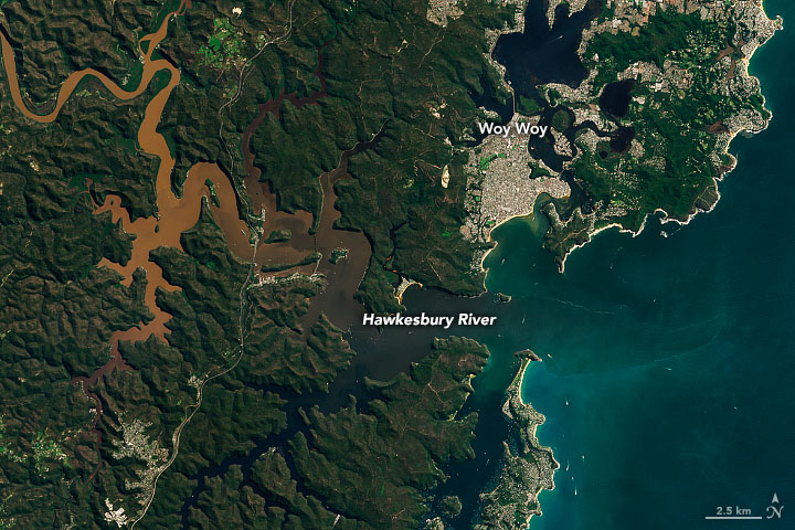
The ground was saturated and rivers were swollen when the Operational Land Imager-2 (OLI-2) on Landsat 9 acquired these images on April 4, 2022. The ongoing impacts of flooding can be seen in the muddy rivers, inundated land, and sediment plumes draining from rivers along the coast.
Near the top of the above image, north of Newcastle, a large lobe of brown floodwater has inundated the Hunter Wetlands. A plume of sediment can also be seen discharging from the mouth of the Hunter River and flowing along the beach in Worimi National Park. Sydney and its harbor can be seen at the bottom left of the image. North of Sydney are the brown, sediment-laden waters of the Hawkesbury River, which is seen in more detail in the image below.

The Hawkesbury River originates to the west, where the Colo and Nepean rivers join. Areas of the Hawkesbury-Nepean Valley were some of the hardest hit in the March 2022 floods, which left thousands of homes damaged and uninhabitable.
Several climate systems influence Australia’s weather. The El Niño Southern Oscillation (ENSO), a coupled atmospheric and ocean circulation pattern in the tropical Pacific. It is currently in its La Niña phase, which typically brings more rain and cooler temperatures to eastern Australia. The Southern Annular Mode (SAM) describes the north or south movement of strong westerly winds in the Southern Hemisphere. With the winds farther south, the SAM has recently been in a positive phase, which increases rainfall in eastern Australia in the summer. The interaction of the two climate modes exacerbates the amount of moisture in the atmosphere available for precipitation, according to research by team at Australian National University, CSIRO, and the University of New South Wales.
The extreme precipitation in the summer of 2021–22 comes after a three-decade period when southeastern Australia has seen an overall decline in rainfall, according to Australia’s Bureau of Meteorology. However, the distribution of rainfall throughout the year has also changed, with summer rains intensifying, winter rains decreasing, and the intensity of short-duration, heavy rainfall increasing.
NASA Earth Observatory image by Joshua Stevens, using Landsat data from the U.S. Geological Survey. Story by Sara E. Pratt.