
For several decades, scientists and astronauts observing Lake Baikal have noticed giant rings in the spring ice on one of the world’s oldest and deepest lakes. Russian researchers first spotted them in satellite images in the early 2000s, but it was after astronauts on the International Space Station photographed two ice rings in April 2009 that the phenomenon become a topic of international study and fascination.
While the rings have attracted speculation and a few conspiracy theories, decades of satellite data and field-based studies have shed light on why they form. “Results of our field surveys show that before and during ice ring manifestation, there are warm eddies that circulate in a clockwise direction under the ice cover,” explained Alexei Kouraev, a hydrologist at the University of Toulouse. “In the eddy center, the ice does not melt — even though the water is warm — because the currents are weak. But on the eddy boundary, the currents are stronger and warmer water leads to rapid melting.”
During field work, Kouraev and his colleagues from France, Russia, and Mongolia drilled holes near ice rings and deployed sensors capable of measuring the temperature and salinity of the water column to a depth of 200 meters (700 feet). Typically the water in the eddies was 1 to 2 degrees Celsius (2 to 4 degrees Fahrenheit) warmer than the surrounding water. They also found that the eddies have a lens-like shape, something that is common in the ocean yet rare in lakes.
The research team is still investigating what causes the eddies, but an analysis of meteorological and hydrological data suggests that they typically get going in autumn, before ice has covered the lake. They likely form because of persistent wind patterns and the inflow of water from certain rivers. The shape of the coastline and lake bottom also play a role in determining where the eddies form and move.

The Landsat image at the top of the page shows an ice ring in the central part of the lake on April 1, 2016. That ring was particularly well-studied because Kouraev and colleagues were nearby, taking measurements of the ice and underlying water. The thin ice of the ring appears darker and more transparent than the whiter, thicker ice surrounding it.
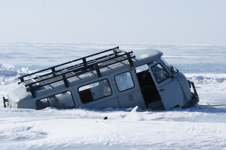
This particular ring was more than just a scientific oddity; it posed a serious hazard because Russians often drive over the ice to get across the lake in the winter. In fact, a few weeks before the satellite image was captured, a van broke through and sank along the edge of this ice ring; the driver and passengers escaped and were rescued. A few days later, a second van (photograph above) broke through and got stuck along the eastern boundary of the ice ring.
To better understand where and how often giant ice rings form, scientists mined all the available satellite imagery of Lake Baikal back to 1969 and identified dozens of rings. Most appeared in March or April and had diameters of about 5 to 7 kilometers (3 to 4 miles) — too big to recognize from the ground but easily seen from above. Some rings were ephemeral, lasting a day or two. Others persisted for weeks or months.
The ring in the image at the top of the page formed off the Nizhneye Izgolovye Cape, one of the most common places for rings to occur. Of the 57 rings detected on Baikal, about 13 formed in this area. According to Kouraev, that is likely because an underwater canyon tends to “trap” eddies in this area. “People often drive a direct line between Nizhneye Izgolovye Cape and Khoboy Cape,” he said, “but we strongly advise that they take a more southerly route to avoid the frequent ice rings in this dangerous region.”
On April 25, 2019, the Moderate Resolution Imaging Spectroradiometer (MODIS) on NASA’s Terra satellite acquired an image (above) of the most recent Baikal ice rings detected by satellites.
For a number of years, one of the most discussed theories in both the scientific community and the news media was that gas hydrates — an ice-like form of methane found at the bottom of the lake — may play a role. Work by Kouraev and colleagues suggests otherwise. When combing through Landsat and MODIS satellite image archives for evidence of rings, scientists identified several over shallow parts of the lake where conditions are not right for gas hydrates. They have also discovered giant rings in satellite imagery of Lake Hovsgol in Mongolia and Lake Teletskoye in Russia’s Altai Republic, both of which are shallower than Lake Baikal and are not known to have gas emissions.
NASA Earth Observatory images by Lauren Dauphin, using Landsat data from the U.S. Geological Survey and MODIS data from NASA EOSDIS/LANCE and GIBS/Worldview. Photograph copyright Alexander Beketov, used with permission. Story by Adam Voiland.