

Editor’s Note: This story is the second part in a series. Please read part 1, part 3, and part 4 for a more complete picture of Amazon deforestation.
For as long as people have inhabited the Amazon rainforest, they have left a mark on the landscape. But never have humans changed the rainforest as dramatically as they have in recent decades.
Since the 1970s, satellites have observed multiple waves of clearcutting as they have spread across the southern Amazon. With fire, chainsaw, axe, and heavy machinery, people have cleared more than a sixth of the forest that once existed. In parts of the Amazon where forests still stand, thinning canopies hint at significant degradation due to logging, drought stress, and understory fire activity.
Satellites have provided scientists with unparalleled views of these changes. In addition to simply tallying how much forest has been cut, scientists have deciphered much about how deforestation has unfolded over four decades. One of the themes that emerges is just how dynamic deforestation has been.
“It is not a uniform process by any means,” said Eugenio Arima, a land system scientist from the University of Texas at Austin. “If you look at deforestation patterns carefully, you can see the fingerprints of economic and institutional history etched into some parts of the landscape.”
One of the best tools for reading the long-term rhythms of deforestation has been the Landsat program. With seven successive satellites, Landsat has taken a snapshot of every part of the Amazon rainforest every two weeks for 47 years, creating the world’s longest, most consistent record of change in the region. Most Landsat satellites have collected 30-meter images, with each pixel representing an area about the size of a baseball field—enough to detect even relatively small clearings and fires. Poring through these many thousands of images of the Amazon, scientists have used the data to analyze everything from how roads have spread, to how the size of cleared parcels has changed, to how deforestation has altered the water cycle.
In the 2000s, Arima was one of many Brazilian scientists who launched a career by studying deforestation as part of the Large-scale Biosphere-Atmosphere Experiment in Amazonia (LBA). This NASA campaign examined how Amazon ecosystems were interconnected and how they were reacting to rapid deforestation, global warming, and cycles of drought. One of Arima’s projects, conducted with Robert Walker of the University of Florida, involved using Landsat to map roads and deforestation patterns, piecing together how those patterns related to what was happening on the ground.
In Peru, Colombia, and other Amazon countries, deforestation has tended to follow rivers, which are often the main transportation routes to remote parts of the rainforest. Prior to the 1970s, Arima explained, this was the case for Brazil as well. (Brazil holds about 60 percent of all the Amazon rainforest within its borders.)
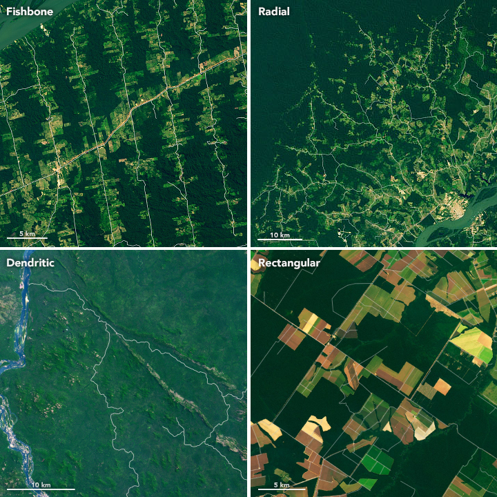
By the 1970s, that began to change dramatically, as forest clearing spread from federal highways in a way that Arima and other scholars call a “fishbone pattern.” The pattern was the product of a major infrastructure and settlement initiative launched by the Brazilian government to develop the rainforest. It was partly an attempt to secure the nation’s borders and stimulate the economy, but it also aimed to provide land and a better life for people living in poverty in the crowded cities of northeastern Brazil. The government unveiled this ambitious road-building and development plan as hundreds of thousands of people were at risk of famine from a severe drought.
“Families were typically given 100 hectares of land and told they could clear 50 percent of it,” explained NASA forest ecologist Douglas Morton. “People would go out with axes or chainsaws and clear a few hectares by hand each year to grow subsistence crops.” However, a few dozen hectares was not enough for most families, given the marginal soil in many areas, and most settlers ended up clearing more than 50 percent or abandoning their small farms for nearby cities.
The highways and 100-hectare plots led to an unmistakable orthogonal pattern on the landscape. The fishbones became particularly common in northern Para state, growing out from Altimira, Uruará, Rurópolis, and other towns along the Trans-Amazonian Highway. Secondary roads, or travessões, were often built perpendicular to the main arteries, and deforestation spread outward in an ordered way as authorities handed out parcels to new settlers.
While thousands of poor families did move into the rainforest in the 1970s, the large-scale, government-run settlement programs did not last. Within a few years, volatile oil prices triggered a recession that caused authorities to scale back support for settlement programs and to look for other ways to stimulate economic growth and develop the Amazon. The focus shifted to loan programs, tax breaks, and other incentives that encouraged wealthy financiers, often from southern Brazil, to invest in large-scale cattle ranching and soy farming operations.
“The style of deforestation changed as official settlement programs wound down,” said Morton. “In the past three decades, it has no longer been families with axes. We’re talking about well-capitalized landowners clearing forests with tractors connected by chains with links as thick as my arm. They would literally rip down the forest, roots and all, to make room for industrial-scale operations.”
It was a change that became visible from space. As a more laissez-faire, free-market approach took hold, deforested plots tended to become larger and blockier, spreading in less linear ways. The plots made available to cattle investors often spanned thousands of hectares, and successful ranchers also bought smaller parcels and consolidated them into larger ones.
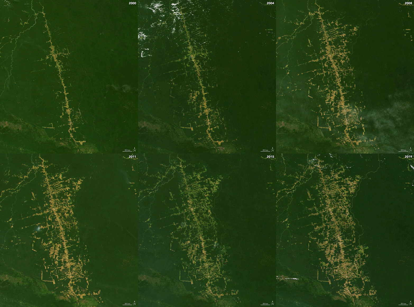
The images above show an example of this more modern large-scale deforestation process playing out in a rough-and-tumble ranching area in a remote part of northern Para, on the western outskirts of the town of Sao Felix de Xingu. Click on the GIF download below the image to see the sequence animated.
After forests are cut, the downed trees and brush are typically left to dry out for a few months or even years, appearing to satellite imagers as a change in the “greenness” of the canopy. This visual clue grows more pronounced over time. When the dry season arrives, fires start springing up in these cleared areas. Often there is so much wood to burn that satellites detect fires over multiple dry days, or even multiple years.
“When fires are unusually large, persistent, and along the forest edge, they are quite likely deforestation fires,” explained Morton. After the smoke has cleared and all the wood turned to ash, people typically spread grass seed and establish pastures for cattle. Today, roughly three quarters of the deforested land in the Brazilian Amazon—some estimates put the number even higher—is used for cattle pasture, with the bulk of it managed by large landowners.
Where the land is flat and well-drained, a distinctive rectangular deforestation pattern—associated with farming—often emerges. In the state of Mato Grosso, for instance, private agricultural cooperatives took a leading role and parceled out large lots to soybean farmers (see lower right of the first image).
“Parts of Mato Grosso feel like you’re in the middle of Iowa—huge fields, straight roads, and completely mechanized operations,” said Matt Hansen, a remote sensing scientist at the University of Maryland. Such landscapes have turned Brazil into the world’s largest exporter of soy, most of which now gets shipped to China.
The transition between the government-directed settlements of the 1970s and the free-market development patterns that followed is particularly pronounced around Itaituba, a town along the Tapajos River in Para. The area was originally targeted for federal colonization, which gave rise to fishbone deforestation south of the river (upper left of first image).
But when the government withdrew financial support, a power vacuum led to a free-for-all north of the river (upper right of first image). Loggers, land grabbers, small farmers, and ranchers all competed for new territory as they followed old logging roads that radiated outward from the town. As loggers and miners pushed into undeveloped parts of the forest, they built roads that generally followed the natural contours of the land and formed curving, dendritic shapes (lower left of first image).

The sequence of natural-color Landsat images above highlights deforestation playing out between 2000-2019 around BR-163, a key highway in Para first built in 1976 but only completely paved in 2019. It links soy-growing areas in the southern Amazon rainforest with an ocean-going port on the Amazon River.
“It is an interesting area because the regional economy was fueled by a gold rush in the 1980s,” explained Arima, noting that the main mining areas are along streams west of the highway. People who got wealthy from gold typically invested in ranching, which caused deforested areas to spread quickly near the highway.
One of the key things to understand about deforestation in the Brazilian Amazon, Arima noted, is that a large fraction of the rainforest is unclaimed, state-owned land, or terras devolutas. Since Brazilian law permits people to claim this land if they occupy it for a year and "improve" it (which usually means clearing it), there has long been a flow of squatters, land speculators, and others willing to head to the frontier.
As long as there are people who need to make a living or a profit and unprotected land is readily available for claiming, the waves of deforestation will likely continue to wash across the world's largest rainforest. “But because of satellites, it won’t go unnoticed,” said Arima. “Scientists, resource managers—anybody really—will easily be able to see exactly where and how the forests are changing.”
NASA Earth Observatory images by Lauren Dauphin, using MODIS data from NASA EOSDIS/LANCE and GIBS/Worldview and Landsat data from the U.S. Geological Survey. Story by Adam Voiland.